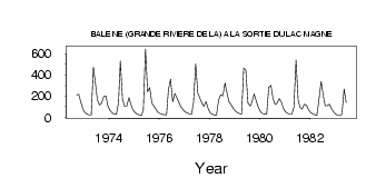
| PointID: | 5135 | Code: | 03EA004 | Latitude (decimal degrees): | 55.26 | Longitude (decimal degrees): | -71.20 | Drainage Area (km2): | 7720.00 | Source: | Hydat | Hydrological Zone: | South and East Hudson Bay | Name: | BALEINE (GRANDE RIVIERE DE LA) A LA SORTIE DU LAC MAGNE |
|---|
| Download | |
|---|---|
| Site Descriptor Information | Site Time Series Data |
| Link to all available data | |
| ID | Year | Jan | Feb | Mar | Apr | May | Jun | Jul | Aug | Sep | Oct | Nov | Dec |
|---|---|---|---|---|---|---|---|---|---|---|---|---|---|
| 5135 | 1972 | 210.00 | 217.00 | 141.00 | 75.00 | ||||||||
| 5135 | 1973 | 45.00 | 30.00 | 23.00 | 22.00 | 474.00 | 331.00 | 163.00 | 115.00 | 136.00 | 195.00 | 201.00 | 109.00 |
| 5135 | 1974 | 64.00 | 43.00 | 31.00 | 27.00 | 136.00 | 532.00 | 168.00 | 102.00 | 104.00 | 187.00 | 117.00 | 71.00 |
| 5135 | 1975 | 45.00 | 31.00 | 22.00 | 17.00 | 68.40 | 645.00 | 242.00 | 278.00 | 134.00 | 103.00 | 75.00 | 48.00 |
| 5135 | 1976 | 34.00 | 27.00 | 24.00 | 22.00 | 260.00 | 360.00 | 146.00 | 223.00 | 181.00 | 135.00 | 98.00 | 70.00 |
| 5135 | 1977 | 51.00 | 40.00 | 33.00 | 30.00 | 138.00 | 503.00 | 230.00 | 179.00 | 130.00 | 104.00 | 149.00 | 80.00 |
| 5135 | 1978 | 41.00 | 28.00 | 23.00 | 21.00 | 164.00 | 210.00 | 201.00 | 325.00 | 235.00 | 145.00 | 119.00 | 83.00 |
| 5135 | 1979 | 57.00 | 43.00 | 35.00 | 30.00 | 464.00 | 445.00 | 134.00 | 106.00 | 146.00 | 219.00 | 154.00 | 92.00 |
| 5135 | 1980 | 52.00 | 35.00 | 29.00 | 27.00 | 285.00 | 300.00 | 173.00 | 121.00 | 133.00 | 175.00 | 144.00 | 80.00 |
| 5135 | 1981 | 50.00 | 37.00 | 31.00 | 29.00 | 93.30 | 539.00 | 162.00 | 94.00 | 78.30 | 124.00 | 112.00 | 70.00 |
| 5135 | 1982 | 46.00 | 32.00 | 24.00 | 18.00 | 169.00 | 336.00 | 204.00 | 108.00 | 108.00 | 123.00 | 81.00 | 50.00 |
| 5135 | 1983 | 31.00 | 21.00 | 14.00 | 29.00 | 266.00 | 137.00 |
 Return to R-Arctic Net Home Page