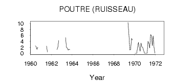
| PointID: | 5112 | Code: | 03DB001 | Latitude (decimal degrees): | 53.73 | Longitude (decimal degrees): | -76.94 | Drainage Area (km2): | 154.00 | Source: | Hydat | Hydrological Zone: | South and East Hudson Bay | Name: | POUTRE (RUISSEAU) |
|---|
| Download | |
|---|---|
| Site Descriptor Information | Site Time Series Data |
| Link to all available data | |
| ID | Year | Jan | Feb | Mar | Apr | May | Jun | Jul | Aug | Sep | Oct | Nov | Dec |
|---|---|---|---|---|---|---|---|---|---|---|---|---|---|
| 5112 | 1960 | 2.57 | 2.27 | 1.33 | 2.02 | ||||||||
| 5112 | 1961 | 2.43 | 0.48 | ||||||||||
| 5112 | 1962 | 1.24 | 2.01 | 4.27 | |||||||||
| 5112 | 1963 | 5.23 | 1.99 | 1.79 | 1.09 | 1.35 | 1.19 | ||||||
| 5112 | 1965 | 4.16 | |||||||||||
| 5112 | 1969 | 10.30 | 6.61 | 1.13 | 1.31 | 4.98 | 4.44 | ||||||
| 5112 | 1970 | 0.00 | 0.00 | 0.00 | 2.00 | 3.66 | 1.92 | 0.73 | 3.42 | 2.13 | 1.96 | 1.00 | 0.00 |
| 5112 | 1971 | 0.00 | 0.00 | 0.00 | 4.00 | 3.36 | 1.78 | 6.24 | 5.96 | 2.51 | 5.79 | 2.00 | 0.00 |
| 5112 | 1972 | 6.73 |
 Return to R-Arctic Net Home Page