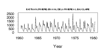
| PointID: | 5102 | Code: | 03CB001 | Latitude (decimal degrees): | 52.19 | Longitude (decimal degrees): | -75.99 | Drainage Area (km2): | 27700.00 | Source: | Hydat | Hydrological Zone: | South and East Hudson Bay | Name: | EASTMAIN (RIVIERE) EN AVAL DE LA RIVIERE A L EAU CLAIRE |
|---|
| Download | |
|---|---|
| Site Descriptor Information | Site Time Series Data |
| Link to all available data | |
| ID | Year | Jan | Feb | Mar | Apr | May | Jun | Jul | Aug | Sep | Oct | Nov | Dec |
|---|---|---|---|---|---|---|---|---|---|---|---|---|---|
| 5102 | 1960 | 918.00 | 501.00 | 919.00 | 798.00 | 866.00 | 665.00 | 448.00 | |||||
| 5102 | 1961 | 255.00 | 175.00 | 129.00 | 296.00 | 1140.00 | 687.00 | 480.00 | 494.00 | 487.00 | 566.00 | 541.00 | 433.00 |
| 5102 | 1962 | 266.00 | 181.00 | 140.00 | 128.00 | 1190.00 | 1030.00 | 392.00 | 375.00 | 596.00 | 494.00 | 362.00 | 241.00 |
| 5102 | 1963 | 147.00 | 112.00 | 98.00 | 166.00 | 872.00 | 1150.00 | 520.00 | 594.00 | 379.00 | 426.00 | 386.00 | 311.00 |
| 5102 | 1964 | 203.00 | 145.00 | 117.00 | 222.00 | 2080.00 | 1440.00 | 541.00 | 650.00 | 851.00 | 863.00 | 509.00 | 305.00 |
| 5102 | 1965 | 192.00 | 142.00 | 118.00 | 112.00 | 996.00 | 1350.00 | 960.00 | 1040.00 | 811.00 | 885.00 | 553.00 | 338.00 |
| 5102 | 1966 | 222.00 | 157.00 | 156.00 | 367.00 | 1150.00 | 1640.00 | 977.00 | 1180.00 | 903.00 | 1090.00 | 819.00 | 601.00 |
| 5102 | 1967 | 294.00 | 188.00 | 142.00 | 132.00 | 1040.00 | 1440.00 | 642.00 | 1320.00 | 604.00 | 570.00 | 765.00 | 464.00 |
| 5102 | 1968 | 261.00 | 174.00 | 143.00 | 459.00 | 1480.00 | 757.00 | 702.00 | 1280.00 | 1280.00 | 1090.00 | 686.00 | 353.00 |
| 5102 | 1969 | 233.00 | 182.00 | 143.00 | 135.00 | 866.00 | 1800.00 | 1320.00 | 779.00 | 712.00 | 975.00 | 771.00 | 513.00 |
| 5102 | 1970 | 347.00 | 249.00 | 179.00 | 160.00 | 1170.00 | 1390.00 | 606.00 | 450.00 | 680.00 | 650.00 | 446.00 | 335.00 |
| 5102 | 1971 | 212.00 | 126.00 | 79.00 | 89.00 | 825.00 | 564.00 | 556.00 | 1010.00 | 974.00 | 1510.00 | 642.00 | 356.00 |
| 5102 | 1972 | 217.00 | 160.00 | 127.00 | 113.00 | 645.00 | 1240.00 | 573.00 | 514.00 | 784.00 | 886.00 | 565.00 | 314.00 |
| 5102 | 1973 | 245.00 | 174.00 | 132.00 | 177.00 | 1900.00 | 1100.00 | 759.00 | 533.00 | 690.00 | 828.00 | 647.00 | 370.00 |
| 5102 | 1974 | 231.00 | 169.00 | 132.00 | 119.00 | 1000.00 | 2530.00 | 641.00 | 332.00 | 497.00 | 992.00 | 599.00 | 347.00 |
| 5102 | 1975 | 207.00 | 146.00 | 113.00 | 131.00 | 1450.00 | 1140.00 | 899.00 | 832.00 | 606.00 | 603.00 | 733.00 | 448.00 |
| 5102 | 1976 | 244.00 | 169.00 | 134.00 | 393.00 | 1820.00 | 1120.00 | 398.00 | 495.00 | 571.00 | 571.00 | 436.00 | 266.00 |
| 5102 | 1977 | 181.00 | 143.00 | 129.00 | 202.00 | 1460.00 | 1350.00 | 511.00 | 718.00 | 1590.00 | 647.00 | 663.00 | 518.00 |
| 5102 | 1978 | 305.00 | 204.00 | 154.00 | 134.00 | 1220.00 | 1090.00 | 875.00 | 1070.00 | 995.00 | 688.00 | 569.00 | 401.00 |
| 5102 | 1979 | 203.00 | 130.00 | 102.00 | 164.00 | 1980.00 | 1400.00 | 720.00 | 686.00 | 921.00 | 1250.00 | 1140.00 | 552.00 |
| 5102 | 1980 | 252.00 | 165.00 | 141.00 | 194.00 | 1450.00 |
 Return to R-Arctic Net Home Page