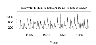
| PointID: | 5081 | Code: | 03AB003 | Latitude (decimal degrees): | 49.69 | Longitude (decimal degrees): | -75.98 | Drainage Area (km2): | 18700.00 | Source: | Hydat | Hydrological Zone: | South and East Hudson Bay | Name: | WASWANIPI (RIVIERE) EN AVAL DE LA RIVIERE OPAWICA |
|---|
| Download | |
|---|---|
| Site Descriptor Information | Site Time Series Data |
| Link to all available data | |
| ID | Year | Jan | Feb | Mar | Apr | May | Jun | Jul | Aug | Sep | Oct | Nov | Dec |
|---|---|---|---|---|---|---|---|---|---|---|---|---|---|
| 5081 | 1962 | 144.00 | 117.00 | 124.00 | 795.00 | 704.00 | 328.00 | 375.00 | 351.00 | 340.00 | 223.00 | 176.00 | |
| 5081 | 1963 | 137.00 | 95.00 | 81.00 | 149.00 | 511.00 | 520.00 | 563.00 | 384.00 | 210.00 | 169.00 | 190.00 | 216.00 |
| 5081 | 1964 | 158.00 | 128.00 | 112.00 | 299.00 | 981.00 | 817.00 | 721.00 | 567.00 | 475.00 | 496.00 | 305.00 | 226.00 |
| 5081 | 1965 | 170.00 | 118.00 | 89.00 | 77.00 | 853.00 | 684.00 | 419.00 | 568.00 | 510.00 | 547.00 | 360.00 | 247.00 |
| 5081 | 1966 | 179.00 | 134.00 | 125.00 | 249.00 | 691.00 | 795.00 | 546.00 | 485.00 | 416.00 | 609.00 | 636.00 | 503.00 |
| 5081 | 1967 | 264.00 | 161.00 | 129.00 | 126.00 | 646.00 | 674.00 | 320.00 | 238.00 | 241.00 | 510.00 | 677.00 | 362.00 |
| 5081 | 1968 | 202.00 | 115.00 | 88.00 | 434.00 | 690.00 | 392.00 | 351.00 | 390.00 | 493.00 | 433.00 | 326.00 | 188.00 |
| 5081 | 1969 | 152.00 | 131.00 | 108.00 | 133.00 | 633.00 | 886.00 | 563.00 | 393.00 | 439.00 | 489.00 | 474.00 | 308.00 |
| 5081 | 1970 | 157.00 | 112.00 | 99.00 | 131.00 | 965.00 | 803.00 | 525.00 | 396.00 | 461.00 | 336.00 | 224.00 | 150.00 |
| 5081 | 1971 | 91.00 | 84.00 | 83.00 | 99.00 | 727.00 | 600.00 | 330.00 | 456.00 | 340.00 | 474.00 | 390.00 | 220.00 |
| 5081 | 1972 | 145.00 | 109.00 | 96.00 | 95.00 | 573.00 | 554.00 | 368.00 | 227.00 | 239.00 | 358.00 | 257.00 | 136.00 |
| 5081 | 1973 | 111.00 | 104.00 | 96.00 | 271.00 | 1010.00 | 580.00 | 480.00 | 429.00 | 470.00 | 445.00 | 319.00 | 238.00 |
| 5081 | 1974 | 172.00 | 128.00 | 113.00 | 164.00 | 1100.00 | 1340.00 | 510.00 | 250.00 | 204.00 | 394.00 | 464.00 | 235.00 |
| 5081 | 1975 | 136.00 | 101.00 | 84.00 | 106.00 | 739.00 | 630.00 | 375.00 | 298.00 | 308.00 | 345.00 | 383.00 | 252.00 |
| 5081 | 1976 | 151.00 | 101.00 | 80.00 | 360.00 | 954.00 | 604.00 | 398.00 | 406.00 | 406.00 | 387.00 | 301.00 | 222.00 |
| 5081 | 1977 | 161.00 | 135.00 | 125.00 | 354.00 | 823.00 | 611.00 | 718.00 | 548.00 | 397.00 | 284.00 | 279.00 | 214.00 |
| 5081 | 1978 | 131.00 | 93.00 | 80.00 | 84.00 | 737.00 | 985.00 | 535.00 | 329.00 | 314.00 | 454.00 | 343.00 | 317.00 |
| 5081 | 1979 | 183.00 | 131.00 | 114.00 | 344.00 | 1190.00 | 800.00 | 439.00 | 562.00 | 510.00 | 696.00 | 536.00 | 404.00 |
| 5081 | 1980 | 207.00 | 132.00 | 104.00 | 353.00 | 723.00 | 320.00 | 302.00 | 429.00 | 415.00 | 618.00 | 456.00 | 275.00 |
| 5081 | 1981 | 185.00 | 161.00 | 211.00 | 884.00 | 1030.00 | 619.00 | 315.00 | 172.00 | 200.00 | 268.00 | 259.00 | 191.00 |
| 5081 | 1982 | 131.00 | 98.00 | 83.00 | 146.00 | 841.00 | 574.00 | 406.00 | 219.00 |
 Return to R-Arctic Net Home Page