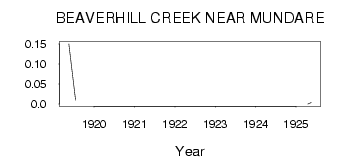
| PointID: | 497 | Code: | 05EB002 | Latitude (decimal degrees): | 53.56 | Longitude (decimal degrees): | -112.50 | Drainage Area (km2): | 2110.00 | Source: | Hydat | Hydrological Zone: | Nelson | Name: | BEAVERHILL CREEK NEAR MUNDARE |
|---|
| Download | |
|---|---|
| Site Descriptor Information | Site Time Series Data |
| Link to all available data | |
| ID | Year | Jan | Feb | Mar | Apr | May | Jun | Jul | Aug | Sep | Oct | Nov | Dec |
|---|---|---|---|---|---|---|---|---|---|---|---|---|---|
| 497 | 1919 | 0.15 | 0.08 | 0.01 | |||||||||
| 497 | 1920 | 9.0e-03 | |||||||||||
| 497 | 1925 | 0.00 | 4.0e-03 |
 Return to R-Arctic Net Home Page