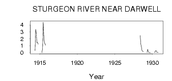
| PointID: | 491 | Code: | 05EA003 | Latitude (decimal degrees): | 53.66 | Longitude (decimal degrees): | -114.61 | Drainage Area (km2): | 322.00 | Source: | Hydat | Hydrological Zone: | Nelson | Name: | STURGEON RIVER NEAR DARWELL |
|---|
| Download | |
|---|---|
| Site Descriptor Information | Site Time Series Data |
| Link to all available data | |
| ID | Year | Jan | Feb | Mar | Apr | May | Jun | Jul | Aug | Sep | Oct | Nov | Dec |
|---|---|---|---|---|---|---|---|---|---|---|---|---|---|
| 491 | 1914 | 0.30 | 3.36 | 2.93 | 1.44 | 1.47 | 1.21 | ||||||
| 491 | 1915 | 0.00 | 0.63 | 4.39 | 2.45 | 1.43 | 1.26 | 1.09 | |||||
| 491 | 1928 | 2.49 | 1.25 | 0.83 | 0.29 | 0.21 | 0.20 | ||||||
| 491 | 1929 | 0.00 | 0.47 | 0.15 | 0.03 | 2.0e-03 | 3.0e-03 | 0.00 | |||||
| 491 | 1930 | 0.00 | 0.20 | 0.30 | 0.23 | 0.02 | 0.02 | 0.03 |
 Return to R-Arctic Net Home Page