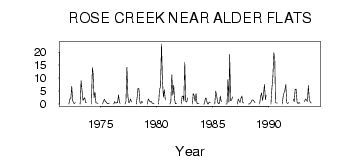
| PointID: | 480 | Code: | 05DE007 | Latitude (decimal degrees): | 52.93 | Longitude (decimal degrees): | -115.01 | Drainage Area (km2): | 551.00 | Source: | Hydat | Hydrological Zone: | Nelson | Name: | ROSE CREEK NEAR ALDER FLATS |
|---|
| Download | |
|---|---|
| Site Descriptor Information | Site Time Series Data |
| Link to all available data | |
| ID | Year | Jan | Feb | Mar | Apr | May | Jun | Jul | Aug | Sep | Oct | Nov | Dec |
|---|---|---|---|---|---|---|---|---|---|---|---|---|---|
| 480 | 1972 | 0.00 | 2.00 | 2.01 | 6.91 | 1.37 | 0.39 | 0.22 | 0.63 | ||||
| 480 | 1973 | 0.00 | 9.00 | 5.16 | 1.39 | 2.00 | 2.49 | 0.48 | 0.48 | ||||
| 480 | 1974 | 0.00 | 14.00 | 11.90 | 2.39 | 4.46 | 0.43 | 0.44 | 0.29 | ||||
| 480 | 1975 | 0.00 | 1.00 | 1.92 | 1.02 | 0.80 | 0.17 | 0.29 | 0.10 | ||||
| 480 | 1976 | 0.00 | 1.00 | 0.43 | 0.49 | 0.61 | 3.52 | 0.59 | 0.28 | ||||
| 480 | 1977 | 0.00 | 1.00 | 14.20 | 2.99 | 0.46 | 0.76 | 1.99 | 0.87 | ||||
| 480 | 1978 | 0.00 | 3.00 | 6.02 | 5.92 | 0.65 | 0.20 | 1.04 | 0.58 | ||||
| 480 | 1979 | 0.00 | 2.00 | 1.45 | 0.87 | 1.09 | 0.42 | 0.17 | 0.28 | ||||
| 480 | 1980 | 0.00 | 6.00 | 6.19 | 23.20 | 9.30 | 2.73 | 5.49 | 1.61 | ||||
| 480 | 1981 | 0.00 | 1.00 | 11.30 | 3.41 | 7.22 | 2.18 | 0.15 | 0.31 | ||||
| 480 | 1982 | 0.00 | 3.00 | 3.11 | 1.27 | 16.00 | 0.94 | 0.80 | 2.38 | ||||
| 480 | 1983 | 0.00 | 4.00 | 3.29 | 1.01 | 4.01 | 0.20 | 0.08 | 0.17 | ||||
| 480 | 1984 | 0.00 | 0.00 | 2.33 | 2.04 | 0.11 | 0.03 | 0.73 | 0.50 | ||||
| 480 | 1985 | 0.00 | 5.00 | 3.08 | 0.81 | 0.09 | 0.30 | 3.08 | 0.92 | ||||
| 480 | 1986 | 0.00 | 0.00 | 9.58 | 0.79 | 19.10 | 1.36 | 1.50 | 2.76 | ||||
| 480 | 1987 | 0.00 | 2.00 | 1.30 | 0.59 | 2.20 | 3.11 | 0.56 | 0.39 | ||||
| 480 | 1988 | 0.00 | 0.00 | 0.38 | 0.87 | 1.63 | 1.51 | 1.06 | 0.51 | ||||
| 480 | 1989 | 0.00 | 3.00 | 4.30 | 1.38 | 3.73 | 7.56 | 1.70 | 3.38 | ||||
| 480 | 1990 | 0.00 | 6.00 | 10.30 | 19.70 | 17.60 | 0.61 | 0.36 | 0.39 | ||||
| 480 | 1991 | 0.00 | 3.00 | 4.50 | 5.26 | 7.49 | 0.52 | 0.23 | 0.59 | ||||
| 480 | 1992 | 2.00 | 1.00 | 5.67 | 5.81 | 0.72 | 0.18 | 0.56 | 0.32 | ||||
| 480 | 1993 | 1.00 | 2.00 | 1.58 | 1.08 | 7.14 | 1.68 | 0.69 | 0.43 |
 Return to R-Arctic Net Home Page