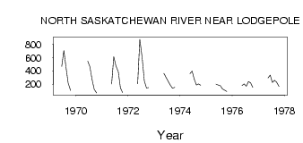
| PointID: | 479 | Code: | 05DE006 | Latitude (decimal degrees): | 53.05 | Longitude (decimal degrees): | -115.20 | Drainage Area (km2): | 20500.00 | Source: | Hydat | Hydrological Zone: | Nelson | Name: | NORTH SASKATCHEWAN RIVER NEAR LODGEPOLE |
|---|
| Download | |
|---|---|
| Site Descriptor Information | Site Time Series Data |
| Link to all available data | |
| ID | Year | Jan | Feb | Mar | Apr | May | Jun | Jul | Aug | Sep | Oct | Nov | Dec |
|---|---|---|---|---|---|---|---|---|---|---|---|---|---|
| 479 | 1969 | 468.00 | 705.00 | 451.00 | 216.00 | 108.00 | |||||||
| 479 | 1970 | 544.00 | 461.00 | 272.00 | 124.00 | 67.20 | |||||||
| 479 | 1971 | 204.00 | 613.00 | 474.00 | 386.00 | 143.00 | 74.10 | ||||||
| 479 | 1972 | 206.00 | 874.00 | 593.00 | 250.00 | 141.00 | 150.00 | ||||||
| 479 | 1973 | 361.00 | 300.00 | 243.00 | 185.00 | 140.00 | 153.00 | ||||||
| 479 | 1974 | 358.00 | 397.00 | 273.00 | 188.00 | 205.00 | 185.00 | ||||||
| 479 | 1975 | 201.00 | 188.00 | 179.00 | 128.00 | 109.00 | 91.40 | ||||||
| 479 | 1976 | 182.00 | 203.00 | 169.00 | 239.00 | 218.00 | 151.00 | ||||||
| 479 | 1977 | 294.00 | 336.00 | 225.00 | 259.00 | 228.00 | 166.00 |
 Return to R-Arctic Net Home Page