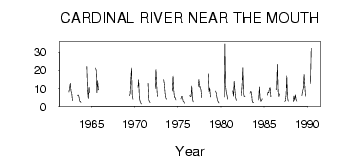
| PointID: | 475 | Code: | 05DD008 | Latitude (decimal degrees): | 52.86 | Longitude (decimal degrees): | -116.59 | Drainage Area (km2): | 495.00 | Source: | Hydat | Hydrological Zone: | Nelson | Name: | CARDINAL RIVER NEAR THE MOUTH |
|---|
| Download | |
|---|---|
| Site Descriptor Information | Site Time Series Data |
| Link to all available data | |
| ID | Year | Jan | Feb | Mar | Apr | May | Jun | Jul | Aug | Sep | Oct | Nov | Dec |
|---|---|---|---|---|---|---|---|---|---|---|---|---|---|
| 475 | 1962 | 8.00 | 10.10 | 12.70 | 8.37 | 7.23 | 3.20 | ||||||
| 475 | 1963 | 5.92 | 6.36 | 5.38 | 2.92 | 2.71 | 2.14 | ||||||
| 475 | 1964 | 22.10 | 8.91 | 4.31 | 10.60 | 7.58 | |||||||
| 475 | 1965 | 21.30 | 19.90 | 7.57 | 14.20 | 9.13 | |||||||
| 475 | 1969 | 5.91 | 6.86 | 14.80 | 21.30 | 5.98 | 3.97 | ||||||
| 475 | 1970 | 10.50 | 14.70 | 4.45 | 2.89 | 1.83 | 1.26 | ||||||
| 475 | 1971 | 12.80 | 3.52 | 2.34 | 2.21 | ||||||||
| 475 | 1972 | 9.95 | 20.50 | 12.00 | 5.57 | ||||||||
| 475 | 1973 | 14.90 | 12.40 | 7.34 | 4.76 | 3.95 | |||||||
| 475 | 1974 | 8.52 | 16.70 | 9.17 | 4.90 | 4.83 | 3.56 | ||||||
| 475 | 1975 | 4.15 | 5.62 | 5.38 | 2.98 | 2.60 | 1.76 | ||||||
| 475 | 1976 | 5.88 | 5.75 | 5.23 | 11.30 | 4.13 | 2.47 | ||||||
| 475 | 1977 | 11.00 | 14.90 | 10.60 | 10.90 | 8.81 | 4.76 | ||||||
| 475 | 1978 | 18.10 | 8.12 | 9.98 | 5.17 | ||||||||
| 475 | 1979 | 8.46 | 7.51 | 4.99 | 3.29 | 2.36 | 1.85 | ||||||
| 475 | 1980 | 5.15 | 34.60 | 11.10 | 7.88 | 6.12 | 4.00 | ||||||
| 475 | 1981 | 8.62 | 5.62 | 14.00 | 8.94 | 4.91 | 3.29 | ||||||
| 475 | 1982 | 5.98 | 11.90 | 21.40 | 6.98 | 5.33 | 5.23 | ||||||
| 475 | 1983 | 7.31 | 8.32 | 7.59 | 3.01 | 2.14 | 2.01 | ||||||
| 475 | 1984 | 3.52 | 10.70 | 4.29 | 2.70 | 3.28 | 4.23 | ||||||
| 475 | 1985 | 6.22 | 7.83 | 7.62 | 9.90 | 10.30 | 5.27 | ||||||
| 475 | 1986 | 9.70 | 9.34 | 23.30 | 8.17 | 5.44 | 6.83 | ||||||
| 475 | 1987 | 2.71 | 3.08 | 6.33 | 16.90 | 5.19 | 2.96 | ||||||
| 475 | 1988 | 2.60 | 5.72 | 3.40 | 6.41 | 3.83 | 2.93 | ||||||
| 475 | 1989 | 6.02 | 8.47 | 10.10 | 17.70 | 11.70 | 5.52 | ||||||
| 475 | 1990 | 12.80 | 32.20 |
 Return to R-Arctic Net Home Page