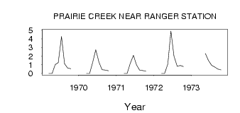
| PointID: | 454 | Code: | 05DB004 | Latitude (decimal degrees): | 52.24 | Longitude (decimal degrees): | -115.30 | Drainage Area (km2): | 95.58 | Source: | Hydat | Hydrological Zone: | Nelson | Name: | PRAIRIE CREEK NEAR RANGER STATION |
|---|
| Download | |
|---|---|
| Site Descriptor Information | Site Time Series Data |
| Link to all available data | |
| ID | Year | Jan | Feb | Mar | Apr | May | Jun | Jul | Aug | Sep | Oct | Nov | Dec |
|---|---|---|---|---|---|---|---|---|---|---|---|---|---|
| 454 | 1969 | 0.00 | 0.00 | 1.03 | 1.26 | 4.26 | 1.12 | 0.63 | 0.55 | ||||
| 454 | 1970 | 0.00 | 0.00 | 1.27 | 2.75 | 1.29 | 0.43 | 0.39 | 0.32 | ||||
| 454 | 1971 | 0.00 | 0.00 | 1.14 | 2.10 | 1.00 | 0.40 | 0.33 | 0.27 | ||||
| 454 | 1972 | 0.00 | 0.00 | 1.11 | 4.90 | 2.00 | 0.83 | 0.93 | 0.80 | ||||
| 454 | 1973 | 2.31 | 1.52 | 0.94 | 0.75 | 0.52 | 0.41 |
 Return to R-Arctic Net Home Page