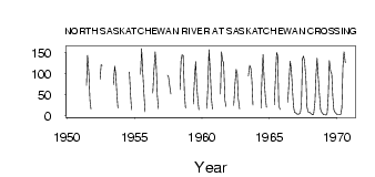
| PointID: | 446 | Code: | 05DA006 | Latitude (decimal degrees): | 51.96 | Longitude (decimal degrees): | -116.72 | Drainage Area (km2): | 1290.00 | Source: | Hydat | Hydrological Zone: | Nelson | Name: | NORTH SASKATCHEWAN RIVER AT SASKATCHEWAN CROSSING |
|---|
| Download | |
|---|---|
| Site Descriptor Information | Site Time Series Data |
| Link to all available data | |
| ID | Year | Jan | Feb | Mar | Apr | May | Jun | Jul | Aug | Sep | Oct | Nov | Dec |
|---|---|---|---|---|---|---|---|---|---|---|---|---|---|
| 446 | 1950 | 59.60 | |||||||||||
| 446 | 1951 | 72.40 | 144.00 | 100.00 | 36.00 | 15.30 | |||||||
| 446 | 1952 | 86.60 | 121.00 | 120.00 | |||||||||
| 446 | 1953 | 74.00 | 118.00 | 98.60 | 51.90 | 17.50 | |||||||
| 446 | 1954 | 104.00 | 54.20 | 14.10 | |||||||||
| 446 | 1955 | 98.20 | 160.00 | 108.00 | 60.70 | 9.58 | |||||||
| 446 | 1956 | 53.70 | 104.00 | 152.00 | 118.00 | 48.20 | 16.70 | ||||||
| 446 | 1957 | 96.20 | 92.50 | 67.70 | 51.10 | ||||||||
| 446 | 1958 | 62.00 | 130.00 | 145.00 | 143.00 | 52.20 | 17.80 | ||||||
| 446 | 1959 | 28.10 | 92.10 | 129.00 | 71.60 | 39.20 | 14.20 | ||||||
| 446 | 1960 | 16.90 | 71.70 | 157.00 | 102.00 | 42.10 | 14.90 | ||||||
| 446 | 1961 | 51.40 | 152.00 | 131.00 | 127.00 | 35.80 | 21.40 | ||||||
| 446 | 1962 | 24.10 | 77.70 | 110.00 | 100.00 | 40.30 | 15.80 | ||||||
| 446 | 1963 | 95.20 | 120.00 | 113.00 | 84.70 | 25.40 | |||||||
| 446 | 1964 | 17.70 | 94.90 | 146.00 | 89.60 | 42.60 | 19.90 | ||||||
| 446 | 1965 | 25.90 | 93.50 | 150.00 | 143.00 | 24.30 | 14.70 | ||||||
| 446 | 1966 | 31.60 | 76.70 | 130.00 | 111.00 | 68.40 | 24.00 | 8.00 | 6.00 | ||||
| 446 | 1967 | 4.00 | 3.00 | 4.00 | 6.00 | 25.20 | 136.00 | 142.00 | 130.00 | 89.00 | 20.80 | 9.00 | 8.00 |
| 446 | 1968 | 6.00 | 4.00 | 2.00 | 3.00 | 32.20 | 97.00 | 137.00 | 95.70 | 57.30 | 14.80 | 8.00 | 5.00 |
| 446 | 1969 | 2.00 | 2.00 | 1.00 | 6.00 | 46.80 | 131.00 | 105.00 | 99.80 | 44.10 | 13.60 | 7.00 | 5.00 |
| 446 | 1970 | 2.00 | 2.00 | 2.00 | 3.00 | 18.40 | 118.00 | 152.00 | 126.00 |
 Return to R-Arctic Net Home Page