| PointID: | 4387 | Code: | 05PB001 | Latitude (decimal degrees): | 48.75 | Longitude (decimal degrees): | -92.20 | Drainage Area (km2): | 5800.00 | Source: | Hydat | Hydrological Zone: | Nelson | Name: | SEINE RIVER NEAR LA SEINE |
|---|
| Download | |
|---|---|
| Site Descriptor Information | Site Time Series Data |
| Link to all available data | |
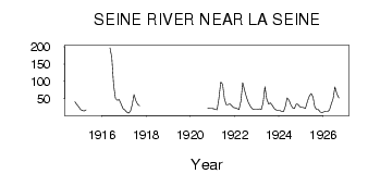
| ID | Year | Jan | Feb | Mar | Apr | May | Jun | Jul | Aug | Sep | Oct | Nov | Dec |
|---|---|---|---|---|---|---|---|---|---|---|---|---|---|
| 4387 | 1914 | 40.60 | 33.00 | 27.00 | |||||||||
| 4387 | 1915 | 19.00 | 16.00 | 14.00 | 17.00 | 40.90 | |||||||
| 4387 | 1916 | 197.00 | 169.00 | 89.60 | 50.80 | 45.30 | 47.80 | 34.00 | 21.00 | ||||
| 4387 | 1917 | 17.00 | 11.00 | 8.00 | 13.00 | 32.30 | 61.50 | 44.60 | 34.00 | 29.00 | |||
| 4387 | 1920 | 23.30 | 22.00 | 22.00 | |||||||||
| 4387 | 1921 | 21.00 | 19.00 | 18.00 | 51.00 | 97.70 | 92.20 | 49.40 | 32.70 | 32.80 | 34.60 | 29.00 | 24.00 |
| 4387 | 1922 | 23.00 | 21.00 | 19.00 | 43.00 | 95.90 | 74.80 | 52.70 | 38.40 | 28.60 | 20.90 | 19.00 | 19.00 |
| 4387 | 1923 | 19.00 | 20.00 | 19.00 | 38.00 | 84.40 | 49.20 | 34.30 | 38.00 | 30.70 | 21.10 | 17.00 | 16.00 |
| 4387 | 1924 | 16.00 | 13.00 | 12.00 | 27.00 | 52.10 | 45.70 | 32.10 | 23.20 | 21.90 | 34.80 | 33.00 | 26.00 |
| 4387 | 1925 | 25.00 | 24.00 | 22.00 | 43.00 | 57.50 | 64.60 | 55.00 | 25.50 | 19.00 | 17.70 | 11.00 | 10.00 |
| 4387 | 1926 | 12.00 | 13.00 | 13.00 | 17.00 | 34.60 | 49.90 | 83.70 | 62.70 | 51.70 |
 Return to R-Arctic Net Home Page