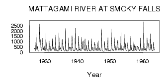
| PointID: | 4366 | Code: | 04LG001 | Latitude (decimal degrees): | 50.06 | Longitude (decimal degrees): | -82.15 | Drainage Area (km2): | 34700.00 | Source: | Hydat | Hydrological Zone: | South and East Hudson Bay | Name: | MATTAGAMI RIVER AT SMOKY FALLS |
|---|
| Download | |
|---|---|
| Site Descriptor Information | Site Time Series Data |
| Link to all available data | |
| ID | Year | Jan | Feb | Mar | Apr | May | Jun | Jul | Aug | Sep | Oct | Nov | Dec |
|---|---|---|---|---|---|---|---|---|---|---|---|---|---|
| 4366 | 1926 | 314.00 | 376.00 | 312.00 | |||||||||
| 4366 | 1927 | 182.00 | 136.00 | 169.00 | 956.00 | 1680.00 | 569.00 | 292.00 | 219.00 | 179.00 | 545.00 | 306.00 | 186.00 |
| 4366 | 1928 | 134.00 | 108.00 | 117.00 | 313.00 | 2650.00 | 1280.00 | 799.00 | 438.00 | 978.00 | 1220.00 | 773.00 | 299.00 |
| 4366 | 1929 | 177.00 | 117.00 | 137.00 | 589.00 | 1320.00 | 966.00 | 407.00 | 237.00 | 388.00 | 529.00 | 605.00 | 194.00 |
| 4366 | 1930 | 130.00 | 127.00 | 139.00 | 249.00 | 1760.00 | 902.00 | 662.00 | 207.00 | 148.00 | 243.00 | 208.00 | 144.00 |
| 4366 | 1931 | 117.00 | 104.00 | 110.00 | 473.00 | 1060.00 | 368.00 | 233.00 | 124.00 | 125.00 | 299.00 | 575.00 | 320.00 |
| 4366 | 1932 | 200.00 | 169.00 | 170.00 | 284.00 | 1260.00 | 295.00 | 337.00 | 272.00 | 424.00 | 501.00 | 487.00 | 206.00 |
| 4366 | 1933 | 158.00 | 164.00 | 136.00 | 683.00 | 1610.00 | 506.00 | 187.00 | 162.00 | 142.00 | 132.00 | 171.00 | 99.00 |
| 4366 | 1934 | 83.00 | 116.00 | 105.00 | 115.00 | 1820.00 | 661.00 | 239.00 | 164.00 | 414.00 | 297.00 | 434.00 | 339.00 |
| 4366 | 1935 | 143.00 | 131.00 | 147.00 | 432.00 | 1230.00 | 648.00 | 392.00 | 318.00 | 227.00 | 538.00 | 252.00 | 141.00 |
| 4366 | 1936 | 112.00 | 109.00 | 116.00 | 183.00 | 2230.00 | 742.00 | 218.00 | 101.00 | 116.00 | 198.00 | 175.00 | 112.00 |
| 4366 | 1937 | 93.00 | 105.00 | 119.00 | 416.00 | 1350.00 | 363.00 | 435.00 | 459.00 | 231.00 | 483.00 | 435.00 | 261.00 |
| 4366 | 1938 | 128.00 | 133.00 | 178.00 | 1180.00 | 1540.00 | 1120.00 | 397.00 | 460.00 | 203.00 | 143.00 | 196.00 | 154.00 |
| 4366 | 1939 | 147.00 | 132.00 | 123.00 | 210.00 | 2250.00 | 767.00 | 444.00 | 221.00 | 320.00 | 392.00 | 253.00 | 128.00 |
| 4366 | 1940 | 125.00 | 124.00 | 116.00 | 180.00 | 1500.00 | 952.00 | 439.00 | 172.00 | 268.00 | 233.00 | 329.00 | 201.00 |
| 4366 | 1941 | 136.00 | 138.00 | 149.00 | 832.00 | 1390.00 | 488.00 | 286.00 | 356.00 | 862.00 | 1070.00 | 629.00 | 502.00 |
| 4366 | 1942 | 254.00 | 171.00 | 180.00 | 927.00 | 1250.00 | 307.00 | 198.00 | 135.00 | 422.00 | 659.00 | 403.00 | 180.00 |
| 4366 | 1943 | 128.00 | 118.00 | 114.00 | 243.00 | 1120.00 | 934.00 | 436.00 | 210.00 | 152.00 | 135.00 | 225.00 | 130.00 |
| 4366 | 1944 | 105.00 | 120.00 | 122.00 | 265.00 | 1260.00 | 419.00 | 164.00 | 260.00 | 439.00 | 459.00 | 254.00 | 156.00 |
| 4366 | 1945 | 125.00 | 119.00 | 271.00 | 931.00 | 647.00 | 745.00 | 397.00 | 183.00 | 204.00 | 236.00 | 384.00 | 185.00 |
| 4366 | 1946 | 140.00 | 137.00 | 288.00 | 777.00 | 1070.00 | 676.00 | 318.00 | 159.00 | 245.00 | 182.00 | 396.00 | 301.00 |
| 4366 | 1947 | 161.00 | 138.00 | 150.00 | 188.00 | 2210.00 | 1680.00 | 436.00 | 226.00 | 157.00 | 111.00 | 99.00 | 82.00 |
| 4366 | 1948 | 78.00 | 77.00 | 81.00 | 594.00 | 1000.00 | 297.00 | 270.00 | 368.00 | 221.00 | 164.00 | 350.00 | 266.00 |
| 4366 | 1949 | 151.00 | 151.00 | 151.00 | 606.00 | 1360.00 | 475.00 | 207.00 | 122.00 | 154.00 | 191.00 | 171.00 | 116.00 |
| 4366 | 1950 | 106.00 | 115.00 | 118.00 | 185.00 | 2170.00 | 1270.00 | 649.00 | 186.00 | 145.00 | 235.00 | 320.00 | 250.00 |
| 4366 | 1951 | 157.00 | 148.00 | 173.00 | 1430.00 | 1210.00 | 434.00 | 354.00 | 202.00 | 165.00 | 574.00 | 636.00 | 384.00 |
| 4366 | 1952 | 183.00 | 173.00 | 173.00 | 770.00 | 1130.00 | 738.00 | 481.00 | 269.00 | 179.00 | 202.00 | 303.00 | 329.00 |
| 4366 | 1953 | 179.00 | 168.00 | 208.00 | 592.00 | 1840.00 | 683.00 | 322.00 | 141.00 | 362.00 | 288.00 | 237.00 | 352.00 |
| 4366 | 1954 | 172.00 | 168.00 | 177.00 | 713.00 | 1690.00 | 626.00 | 389.00 | 232.00 | 195.00 | 806.00 | 567.00 | 219.00 |
| 4366 | 1955 | 161.00 | 147.00 | 146.00 | 920.00 | 715.00 | 358.00 | 117.00 | 82.00 | 72.60 | 319.00 | 284.00 | 151.00 |
| 4366 | 1956 | 133.00 | 127.00 | 140.00 | 233.00 | 1500.00 | 871.00 | 400.00 | 216.00 | 336.00 | 215.00 | 141.00 | 134.00 |
| 4366 | 1957 | 124.00 | 126.00 | 144.00 | 797.00 | 1020.00 | 480.00 | 607.00 | 141.00 | 205.00 | 226.00 | 564.00 | 278.00 |
| 4366 | 1958 | 175.00 | 155.00 | 168.00 | 588.00 | 524.00 | 564.00 | 353.00 | 207.00 | 426.00 | 435.00 | 489.00 | 216.00 |
| 4366 | 1959 | 149.00 | 135.00 | 144.00 | 287.00 | 1330.00 | 431.00 | 138.00 | 170.00 | 224.00 | 408.00 | 389.00 | 188.00 |
| 4366 | 1960 | 156.00 | 146.00 | 156.00 | 547.00 | 2870.00 | 623.00 | 227.00 | 256.00 | 167.00 | 208.00 | 341.00 | 228.00 |
| 4366 | 1961 | 144.00 | 122.00 | 137.00 | 535.00 | 1340.00 | 862.00 | 782.00 | 354.00 | 861.00 | 710.00 | 471.00 | 325.00 |
| 4366 | 1962 | 197.00 | 188.00 | 180.00 | 308.00 | 1730.00 | 593.00 | 186.00 | 334.00 | 773.00 | 251.00 | 174.00 | 178.00 |
| 4366 | 1963 | 134.00 | 130.00 | 145.00 | 411.00 | 950.00 | 709.00 | 285.00 | 194.00 | 219.00 |
| Other Close Sites | ||||||
|---|---|---|---|---|---|---|
| PointID | Latitude | Longitude | Drainage Area | Source | Name | |
| 4368 | 50.00 | -82.16 | 34700.00 | Hydat | MATTAGAMI RIVER AT LITTLE LONG RAPIDS | |
 Return to R-Arctic Net Home Page