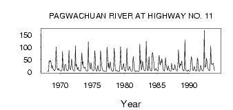
| PointID: | 4355 | Code: | 04JD005 | Latitude (decimal degrees): | 49.76 | Longitude (decimal degrees): | -85.23 | Drainage Area (km2): | 2020.00 | Source: | Hydat | Hydrological Zone: | South and East Hudson Bay | Name: | PAGWACHUAN RIVER AT HIGHWAY NO. 11 |
|---|
| Download | |
|---|---|
| Site Descriptor Information | Site Time Series Data |
| Link to all available data | |
| ID | Year | Jan | Feb | Mar | Apr | May | Jun | Jul | Aug | Sep | Oct | Nov | Dec |
|---|---|---|---|---|---|---|---|---|---|---|---|---|---|
| 4355 | 1968 | 3.00 | 2.00 | 1.00 | 46.00 | 41.90 | 41.00 | 46.40 | 29.20 | 13.80 | 26.30 | 19.00 | 8.00 |
| 4355 | 1969 | 6.00 | 5.00 | 4.00 | 19.00 | 101.00 | 49.20 | 15.60 | 8.31 | 6.77 | 14.10 | 8.00 | 6.00 |
| 4355 | 1970 | 4.00 | 3.00 | 3.00 | 8.00 | 82.50 | 26.80 | 12.60 | 3.10 | 26.00 | 29.20 | 30.00 | 10.00 |
| 4355 | 1971 | 6.00 | 5.00 | 3.00 | 12.00 | 86.90 | 29.20 | 12.70 | 8.88 | 22.10 | 52.30 | 32.00 | 14.00 |
| 4355 | 1972 | 6.00 | 3.00 | 3.00 | 6.00 | 105.00 | 22.90 | 31.00 | 14.80 | 9.42 | 19.60 | 8.00 | 5.00 |
| 4355 | 1973 | 4.00 | 3.00 | 4.00 | 45.00 | 77.70 | 28.80 | 43.10 | 16.90 | 15.60 | 15.20 | 20.00 | 12.00 |
| 4355 | 1974 | 5.00 | 4.00 | 3.00 | 4.00 | 122.00 | 40.10 | 30.50 | 15.90 | 11.00 | 37.20 | 22.00 | 9.00 |
| 4355 | 1975 | 6.00 | 5.00 | 4.00 | 10.00 | 86.30 | 57.80 | 10.70 | 4.26 | 2.28 | 14.50 | 26.00 | 9.00 |
| 4355 | 1976 | 5.00 | 3.00 | 3.00 | 85.00 | 49.00 | 25.30 | 11.60 | 6.86 | 3.47 | 4.12 | 2.00 | 2.00 |
| 4355 | 1977 | 1.00 | 1.00 | 3.00 | 101.00 | 54.10 | 18.30 | 36.00 | 11.60 | 32.90 | 40.40 | 20.00 | 8.00 |
| 4355 | 1978 | 4.00 | 3.00 | 2.00 | 5.00 | 95.60 | 71.10 | 15.30 | 5.33 | 3.29 | 5.01 | 4.00 | 2.00 |
| 4355 | 1979 | 2.00 | 1.00 | 2.00 | 27.00 | 102.00 | 38.50 | 10.60 | 9.50 | 14.50 | 25.80 | 34.00 | 10.00 |
| 4355 | 1980 | 5.00 | 3.00 | 3.00 | 40.00 | 95.40 | 25.90 | 6.43 | 5.83 | 12.60 | 22.10 | 13.00 | 5.00 |
| 4355 | 1981 | 3.00 | 2.00 | 4.00 | 42.00 | 62.10 | 29.50 | 7.58 | 1.75 | 1.08 | 2.60 | 4.00 | 3.00 |
| 4355 | 1982 | 2.00 | 1.00 | 1.00 | 6.00 | 113.00 | 31.10 | 48.70 | 7.21 | 16.90 | 43.00 | 26.00 | 17.00 |
| 4355 | 1983 | 6.00 | 4.00 | 4.00 | 11.00 | 124.00 | 25.60 | 17.70 | 3.37 | 14.30 | 60.60 | 17.00 | 10.00 |
| 4355 | 1984 | 5.00 | 4.00 | 3.00 | 74.00 | 77.90 | 59.40 | 38.90 | 13.10 | 4.75 | 10.00 | 13.00 | 10.00 |
| 4355 | 1985 | 5.00 | 4.00 | 3.00 | 49.00 | 66.60 | 39.90 | 26.80 | 44.20 | 36.30 | 52.50 | 40.00 | 12.00 |
| 4355 | 1986 | 5.00 | 4.00 | 3.00 | 34.00 | 57.20 | 28.20 | 18.00 | 6.54 | 7.50 | 24.40 | 13.00 | 6.00 |
| 4355 | 1987 | 3.00 | 3.00 | 3.00 | 34.00 | 20.20 | 12.30 | 7.96 | 10.80 | 9.18 | 28.50 | 20.00 | 11.00 |
| 4355 | 1988 | 5.00 | 3.00 | 3.00 | 38.00 | 88.80 | 40.30 | 15.30 | 32.70 | 26.30 | 27.20 | 44.00 | 18.00 |
| 4355 | 1989 | 7.00 | 5.00 | 3.00 | 20.00 | 130.00 | 17.60 | 4.62 | 4.47 | 2.17 | 3.78 | 8.00 | 4.00 |
| 4355 | 1990 | 2.00 | 2.00 | 4.00 | 46.00 | 61.80 | 48.50 | 27.00 | 4.40 | 4.57 | 17.70 | 21.00 | 8.00 |
| 4355 | 1991 | 4.00 | 3.00 | 3.00 | 56.00 | 49.50 | 14.90 | 3.37 | 2.26 | 5.00 | 25.30 | 23.00 | 10.00 |
| 4355 | 1992 | 5.00 | 4.00 | 3.00 | 16.00 | 169.00 | 25.40 | 17.10 | 29.80 | 55.20 | 42.70 | 21.00 | 12.00 |
| 4355 | 1993 | 8.00 | 5.00 | 4.00 | 38.00 | 105.00 | 31.10 | 31.40 | 29.80 | 33.20 | 34.10 | 18.00 | 5.00 |
 Return to R-Arctic Net Home Page