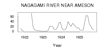
| PointID: | 4350 | Code: | 04JC001 | Latitude (decimal degrees): | 49.79 | Longitude (decimal degrees): | -84.52 | Drainage Area (km2): | 2410.00 | Source: | Hydat | Hydrological Zone: | South and East Hudson Bay | Name: | NAGAGAMI RIVER NEAR AMESON |
|---|
| Download | |
|---|---|
| Site Descriptor Information | Site Time Series Data |
| Link to all available data | |
| ID | Year | Jan | Feb | Mar | Apr | May | Jun | Jul | Aug | Sep | Oct | Nov | Dec |
|---|---|---|---|---|---|---|---|---|---|---|---|---|---|
| 4350 | 1921 | 11.50 | 2.00 | 0.00 | |||||||||
| 4350 | 1922 | 73.50 | 20.30 | 6.28 | 3.43 | 2.21 | 1.42 | 1.00 | 1.00 | ||||
| 4350 | 1923 | 1.00 | 0.00 | 0.00 | 4.00 | 21.20 | 20.10 | 17.70 | 6.63 | 6.63 | 15.60 | 33.00 | 37.00 |
| 4350 | 1924 | 13.00 | 5.00 | 5.00 | 14.00 | 38.70 | 28.30 | 19.40 | 31.70 | 27.10 | 19.00 | 13.00 | 14.00 |
| 4350 | 1925 | 4.00 | 4.00 | 5.00 | 37.00 | 64.00 | 62.10 | 29.70 | 20.50 | 8.47 | 6.89 |
 Return to R-Arctic Net Home Page