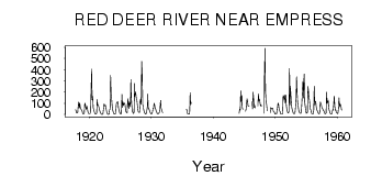
| PointID: | 435 | Code: | 05CK002 | Latitude (decimal degrees): | 50.96 | Longitude (decimal degrees): | -110.02 | Drainage Area (km2): | 46800.00 | Source: | Hydat | Hydrological Zone: | Nelson | Name: | RED DEER RIVER NEAR EMPRESS |
|---|
| Download | |
|---|---|
| Site Descriptor Information | Site Time Series Data |
| Link to all available data | |
| ID | Year | Jan | Feb | Mar | Apr | May | Jun | Jul | Aug | Sep | Oct | Nov | Dec |
|---|---|---|---|---|---|---|---|---|---|---|---|---|---|
| 435 | 1917 | 43.30 | 32.00 | 12.00 | |||||||||
| 435 | 1918 | 12.00 | 12.00 | 73.00 | 112.00 | 58.40 | 99.50 | 65.00 | 51.90 | 40.40 | 38.40 | 22.00 | 8.00 |
| 435 | 1919 | 6.00 | 6.00 | 8.00 | 103.00 | 89.20 | 60.00 | 45.10 | 73.40 | 49.30 | 23.00 | 11.00 | 7.00 |
| 435 | 1920 | 8.00 | 10.00 | 11.00 | 211.00 | 406.00 | 130.00 | 164.00 | 63.30 | 37.60 | 24.90 | 11.00 | 6.00 |
| 435 | 1921 | 4.00 | 5.00 | 10.00 | 135.00 | 82.50 | 82.30 | 68.10 | 54.30 | 32.50 | 19.40 | 9.00 | 4.00 |
| 435 | 1922 | 1.00 | 0.00 | 6.00 | 48.00 | 92.90 | 89.00 | 73.00 | 80.40 | 49.50 | 25.70 | 10.00 | 3.00 |
| 435 | 1923 | 1.00 | 1.00 | 3.00 | 40.00 | 46.60 | 350.00 | 179.00 | 141.00 | 72.90 | 43.00 | 22.00 | 10.00 |
| 435 | 1924 | 3.00 | 5.00 | 6.00 | 32.00 | 97.00 | 102.00 | 114.00 | 113.00 | 57.70 | 39.40 | 19.00 | 9.00 |
| 435 | 1925 | 4.00 | 4.00 | 12.00 | 179.00 | 62.30 | 111.00 | 78.40 | 101.00 | 99.50 | 86.00 | 42.00 | 21.00 |
| 435 | 1926 | 14.00 | 16.00 | 140.00 | 103.00 | 52.70 | 114.00 | 97.70 | 68.10 | 312.00 | 135.00 | 61.00 | 27.00 |
| 435 | 1927 | 16.00 | 7.00 | 20.00 | 277.00 | 162.00 | 201.00 | 179.00 | 137.00 | 126.00 | 79.50 | 36.00 | 23.00 |
| 435 | 1928 | 20.00 | 18.00 | 116.00 | 137.00 | 90.20 | 475.00 | 358.00 | 90.90 | 65.50 | 38.90 | 20.00 | 11.00 |
| 435 | 1929 | 6.00 | 3.00 | 17.00 | 40.00 | 78.20 | 183.00 | 57.20 | 52.30 | 39.70 | 26.80 | 14.00 | 7.00 |
| 435 | 1930 | 4.00 | 12.00 | 23.00 | 55.00 | 55.40 | 99.70 | 87.80 | 57.90 | 47.60 | 31.80 | 22.00 | 8.00 |
| 435 | 1931 | 6.00 | 5.00 | 9.00 | 20.00 | 34.50 | 102.00 | 125.00 | 51.90 | 41.90 | 24.50 | 14.00 | |
| 435 | 1932 | 36.00 | |||||||||||
| 435 | 1935 | 48.80 | 34.30 | 8.00 | 6.00 | ||||||||
| 435 | 1936 | 4.00 | 4.00 | 7.00 | 195.00 | 85.00 | 109.00 | ||||||
| 435 | 1944 | 10.00 | 48.00 | 37.40 | 211.00 | 113.00 | 171.00 | 61.80 | 46.20 | ||||
| 435 | 1945 | 30.00 | 43.00 | 97.90 | 141.00 | 117.00 | 74.50 | 73.00 | 72.10 | ||||
| 435 | 1946 | 115.00 | 49.60 | 199.00 | 139.00 | 62.40 | 80.70 | 56.80 | |||||
| 435 | 1947 | 76.00 | 182.00 | 124.00 | 138.00 | 110.00 | 76.30 | 86.40 | 74.90 | ||||
| 435 | 1948 | 10.00 | 345.00 | 591.00 | 215.00 | 113.00 | 92.60 | 45.70 | 34.10 | ||||
| 435 | 1949 | 15.00 | 61.00 | 49.00 | 52.70 | 56.70 | 52.90 | 27.00 | 24.10 | 18.00 | 6.00 | ||
| 435 | 1950 | 2.00 | 3.00 | 4.00 | 50.00 | 49.60 | 91.70 | 101.00 | 63.10 | 31.90 | 30.00 | 8.00 | 3.00 |
| 435 | 1951 | 3.00 | 3.00 | 3.00 | 167.00 | 168.00 | 135.00 | 172.00 | 103.00 | 172.00 | 80.00 | 46.00 | 27.00 |
| 435 | 1952 | 14.00 | 13.00 | 26.00 | 412.00 | 87.70 | 253.00 | 190.00 | 103.00 | 56.90 | 41.80 | 22.00 | 11.00 |
| 435 | 1953 | 7.00 | 8.00 | 13.00 | 67.00 | 137.00 | 338.00 | 197.00 | 108.00 | 75.20 | 38.80 | 24.00 | 13.00 |
| 435 | 1954 | 10.00 | 11.00 | 18.00 | 105.00 | 207.00 | 296.00 | 147.00 | 282.00 | 362.00 | 109.00 | 66.00 | 28.00 |
| 435 | 1955 | 11.00 | 15.00 | 13.00 | 250.00 | 218.00 | 146.00 | 127.00 | 66.30 | 42.70 | 37.90 | 10.00 | 6.00 |
| 435 | 1956 | 6.00 | 8.00 | 35.00 | 252.00 | 86.60 | 118.00 | 114.00 | 78.10 | 52.20 | 35.70 | 26.00 | 12.00 |
| 435 | 1957 | 8.00 | 6.00 | 21.00 | 111.00 | 100.00 | 85.10 | 62.60 | 55.30 | 42.60 | 37.00 | 29.00 | 14.00 |
| 435 | 1958 | 5.00 | 6.00 | 12.00 | 198.00 | 98.60 | 113.00 | 129.00 | 63.40 | 45.90 | 31.00 | 12.00 | 7.00 |
| 435 | 1959 | 5.00 | 3.00 | 23.00 | 41.00 | 37.40 | 94.60 | 166.00 | 72.70 | 36.30 | 37.40 | 17.00 | 15.00 |
| 435 | 1960 | 8.00 | 9.00 | 55.00 | 150.00 | 68.90 | 91.60 | 87.50 | 67.80 | 37.80 |
 Return to R-Arctic Net Home Page