| PointID: | 4348 | Code: | 04JA001 | Latitude (decimal degrees): | 49.78 | Longitude (decimal degrees): | -84.10 | Drainage Area (km2): | 3780.00 | Source: | Hydat | Hydrological Zone: | South and East Hudson Bay | Name: | KABINAKAGAMI RIVER NEAR KABINA |
|---|
| Download | |
|---|---|
| Site Descriptor Information | Site Time Series Data |
| Link to all available data | |
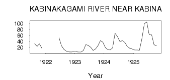
| ID | Year | Jan | Feb | Mar | Apr | May | Jun | Jul | Aug | Sep | Oct | Nov | Dec |
|---|---|---|---|---|---|---|---|---|---|---|---|---|---|
| 4348 | 1921 | 32.70 | 23.70 | 32.10 | 17.00 | ||||||||
| 4348 | 1922 | 52.70 | 26.10 | 14.30 | 8.09 | 5.71 | 5.00 | 6.00 | |||||
| 4348 | 1923 | 6.00 | 5.00 | 5.00 | 10.00 | 30.00 | 27.10 | 21.20 | 10.20 | 15.50 | 26.20 | 43.00 | 38.00 |
| 4348 | 1924 | 20.00 | 13.00 | 12.00 | 19.00 | 67.20 | 56.70 | 39.60 | 43.00 | 37.00 | 23.90 | 18.00 | 15.00 |
| 4348 | 1925 | 12.00 | 12.00 | 11.00 | 48.00 | 99.40 | 105.00 | 62.20 | 62.60 | 29.30 | 25.50 |
 Return to R-Arctic Net Home Page