| PointID: | 4346 | Code: | 04GF001 | Latitude (decimal degrees): | 51.52 | Longitude (decimal degrees): | -85.07 | Drainage Area (km2): | 1890.00 | Source: | Hydat | Hydrological Zone: | South and East Hudson Bay | Name: | MUSWABIK RIVER AT OUTLET OF MUSWABIK LAKE |
|---|
| Download | |
|---|---|
| Site Descriptor Information | Site Time Series Data |
| Link to all available data | |
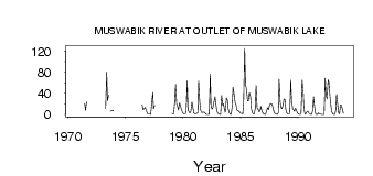
| ID | Year | Jan | Feb | Mar | Apr | May | Jun | Jul | Aug | Sep | Oct | Nov | Dec |
|---|---|---|---|---|---|---|---|---|---|---|---|---|---|
| 4346 | 1970 | 34.90 | |||||||||||
| 4346 | 1971 | 20.70 | 7.46 | 23.70 | |||||||||
| 4346 | 1973 | 11.00 | 80.00 | 26.10 | 36.40 | 6.47 | 7.17 | 8.00 | 7.00 | ||||
| 4346 | 1976 | 18.30 | 8.89 | 10.50 | 13.80 | 10.10 | 4.00 | 1.00 | |||||
| 4346 | 1977 | 1.00 | 1.00 | 0.00 | 21.00 | 41.70 | 10.40 | 17.20 | |||||
| 4346 | 1979 | 2.00 | 1.00 | 1.00 | 24.00 | 57.00 | 20.40 | 14.20 | 8.58 | 22.10 | 17.30 | 10.00 | 4.00 |
| 4346 | 1980 | 2.00 | 1.00 | 1.00 | 6.00 | 63.50 | 9.57 | 4.04 | 3.03 | 6.77 | 23.60 | 15.00 | 3.00 |
| 4346 | 1981 | 1.00 | 1.00 | 2.00 | 3.00 | 63.40 | 25.00 | 10.10 | 3.76 | 4.10 | 4.72 | 4.00 | 2.00 |
| 4346 | 1982 | 0.00 | 0.00 | 0.00 | 0.00 | 76.30 | 15.10 | 10.10 | 13.00 | 24.30 | 33.80 | 21.00 | 6.00 |
| 4346 | 1983 | 2.00 | 1.00 | 0.00 | 0.00 | 36.20 | 17.80 | 20.00 | 8.10 | 4.10 | 31.10 | 27.00 | 10.00 |
| 4346 | 1984 | 3.00 | 0.00 | 0.00 | 16.00 | 51.60 | 38.50 | 21.90 | 19.10 | 8.30 | 8.15 | 6.00 | 4.00 |
| 4346 | 1985 | 2.00 | 2.00 | 1.00 | 22.00 | 125.00 | 58.20 | 46.30 | 25.40 | 25.70 | 41.20 | 34.00 | 11.00 |
| 4346 | 1986 | 4.00 | 1.00 | 1.00 | 11.00 | 54.90 | 11.70 | 9.95 | 5.14 | 6.96 | 14.90 | 7.00 | 2.00 |
| 4346 | 1987 | 1.00 | 0.00 | 0.00 | 8.00 | 12.70 | 9.22 | 17.40 | 20.40 | 20.80 | 16.50 | 9.00 | 3.00 |
| 4346 | 1988 | 1.00 | 1.00 | 0.00 | 3.00 | 66.50 | 24.00 | 13.10 | 10.90 | 18.20 | 29.40 | 28.00 | 10.00 |
| 4346 | 1989 | 3.00 | 1.00 | 1.00 | 1.00 | 65.20 | 28.30 | 11.00 | 9.44 | 6.20 | 12.10 | 8.00 | 3.00 |
| 4346 | 1990 | 1.00 | 0.00 | 0.00 | 3.00 | 64.80 | 41.40 | 9.42 | 0.74 | 1.42 | 5.10 | 6.00 | 3.00 |
| 4346 | 1991 | 1.00 | 0.00 | 0.00 | 8.00 | 33.70 | 13.40 | 0.65 | 0.30 | 0.18 | 2.99 | 1.00 | 1.00 |
| 4346 | 1992 | 0.00 | 0.00 | 0.00 | 0.00 | 68.70 | 36.90 | 29.80 | 65.70 | 61.50 | 34.20 | 15.00 | 5.00 |
| 4346 | 1993 | 1.00 | 0.00 | 0.00 | 7.00 | 38.30 | 20.00 | 4.06 | 1.22 | 18.20 | 17.60 | 10.00 | 2.00 |
 Return to R-Arctic Net Home Page