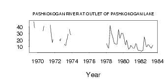
| PointID: | 4339 | Code: | 04GA003 | Latitude (decimal degrees): | 51.03 | Longitude (decimal degrees): | -90.20 | Drainage Area (km2): | 2230.00 | Source: | Hydat | Hydrological Zone: | South and East Hudson Bay | Name: | PASHKOKOGAN RIVER AT OUTLET OF PASHKOKOGAN LAKE |
|---|
| Download | |
|---|---|
| Site Descriptor Information | Site Time Series Data |
| Link to all available data | |
| ID | Year | Jan | Feb | Mar | Apr | May | Jun | Jul | Aug | Sep | Oct | Nov | Dec |
|---|---|---|---|---|---|---|---|---|---|---|---|---|---|
| 4339 | 1969 | 48.10 | 38.60 | ||||||||||
| 4339 | 1970 | 34.00 | 41.40 | ||||||||||
| 4339 | 1971 | 43.00 | 33.80 | 24.10 | 16.30 | 21.20 | |||||||
| 4339 | 1972 | 21.10 | 19.10 | 22.40 | 27.00 | ||||||||
| 4339 | 1973 | 14.00 | 12.00 | 12.00 | 19.90 | 22.40 | 29.40 | 36.60 | 30.20 | 28.00 | |||
| 4339 | 1978 | 15.00 | 12.00 | 9.00 | 8.00 | 20.10 | 42.20 | 36.20 | 30.20 | 27.70 | 23.60 | 19.00 | 15.00 |
| 4339 | 1979 | 15.00 | 14.00 | 14.00 | 14.00 | 27.10 | 36.10 | 29.30 | 22.80 | 27.20 | 30.70 | 30.00 | 30.00 |
| 4339 | 1980 | 26.00 | 21.00 | 15.00 | 13.00 | 20.00 | 17.40 | 10.90 | 6.26 | 7.20 | 8.51 | 12.00 | 11.00 |
| 4339 | 1981 | 10.00 | 8.00 | 8.00 | 8.00 | 10.70 | 14.70 | 13.90 | 8.20 | 5.20 | 4.26 | 4.00 | 4.00 |
| 4339 | 1982 | 4.00 | 3.00 | 4.00 | 4.00 | 12.40 | 25.10 | 21.30 | 14.10 | 10.10 | 10.30 | 13.00 | 13.00 |
| 4339 | 1983 | 12.00 | 10.00 | 9.00 | 8.00 | 10.60 | 12.50 |
 Return to R-Arctic Net Home Page