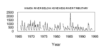
| PointID: | 4330 | Code: | 04DC001 | Latitude (decimal degrees): | 54.51 | Longitude (decimal degrees): | -87.23 | Drainage Area (km2): | 50000.00 | Source: | Hydat | Hydrological Zone: | South and East Hudson Bay | Name: | WINISK RIVER BELOW ASHEWEIG RIVER TRIBUTARY |
|---|
| Download | |
|---|---|
| Site Descriptor Information | Site Time Series Data |
| Link to all available data | |
| ID | Year | Jan | Feb | Mar | Apr | May | Jun | Jul | Aug | Sep | Oct | Nov | Dec |
|---|---|---|---|---|---|---|---|---|---|---|---|---|---|
| 4330 | 1965 | 762.00 | 721.00 | 450.00 | |||||||||
| 4330 | 1966 | 289.00 | 202.00 | 136.00 | 119.00 | 772.00 | 1430.00 | 1250.00 | 743.00 | 789.00 | 680.00 | 577.00 | 334.00 |
| 4330 | 1967 | 199.00 | 134.00 | 107.00 | 102.00 | 284.00 | 1180.00 | 699.00 | 416.00 | 238.00 | 194.00 | 199.00 | 146.00 |
| 4330 | 1968 | 119.00 | 105.00 | 94.00 | 123.00 | 535.00 | 487.00 | 626.00 | 668.00 | 597.00 | 805.00 | 1020.00 | 428.00 |
| 4330 | 1969 | 253.00 | 185.00 | 132.00 | 130.00 | 873.00 | 831.00 | 973.00 | 656.00 | 829.00 | 1480.00 | 821.00 | 448.00 |
| 4330 | 1970 | 268.00 | 171.00 | 123.00 | 115.00 | 780.00 | 1050.00 | 702.00 | 700.00 | 798.00 | 1220.00 | 857.00 | 429.00 |
| 4330 | 1971 | 271.00 | 185.00 | 135.00 | 127.00 | 1420.00 | 1040.00 | 566.00 | 796.00 | 563.00 | 857.00 | 564.00 | 297.00 |
| 4330 | 1972 | 188.00 | 139.00 | 112.00 | 97.00 | 785.00 | 939.00 | 663.00 | 584.00 | 641.00 | 915.00 | 534.00 | 317.00 |
| 4330 | 1973 | 208.00 | 155.00 | 129.00 | 118.00 | 1220.00 | 1250.00 | 1220.00 | 613.00 | 431.00 | 459.00 | 393.00 | 286.00 |
| 4330 | 1974 | 519.00 | 794.00 | 637.00 | 382.00 | 235.00 | |||||||
| 4330 | 1975 | 163.00 | 128.00 | 107.00 | 96.00 | 337.00 | 930.00 | 891.00 | 1240.00 | 751.00 | 521.00 | 417.00 | 247.00 |
| 4330 | 1976 | 170.00 | 131.00 | 108.00 | 186.00 | 1090.00 | 747.00 | 482.00 | 299.00 | 207.00 | 176.00 | 136.00 | 105.00 |
| 4330 | 1977 | 87.00 | 74.00 | 66.00 | 193.00 | 547.00 | 364.00 | 322.00 | 262.00 | 325.00 | 366.00 | 291.00 | 195.00 |
| 4330 | 1978 | 133.00 | 108.00 | 96.00 | 93.00 | 450.00 | 270.00 | ||||||
| 4330 | 1979 | 205.00 | 154.00 | 121.00 | 315.00 | 926.00 | 653.00 | 481.00 | 501.00 | 501.00 | 570.00 | 503.00 | 341.00 |
| 4330 | 1980 | 245.00 | 154.00 | 97.00 | 115.00 | 824.00 | 495.00 | 462.00 | 387.00 | 460.00 | 771.00 | 462.00 | 285.00 |
| 4330 | 1981 | 208.00 | 158.00 | 128.00 | 146.00 | 1160.00 | 840.00 | 470.00 | 259.00 | ||||
| 4330 | 1982 | 1010.00 | 620.00 | 535.00 | 618.00 | 501.00 | 314.00 | ||||||
| 4330 | 1983 | 209.00 | 154.00 | 115.00 | 88.00 | 203.00 | 551.00 | 505.00 | 345.00 | 320.00 | 393.00 | 345.00 | 252.00 |
| 4330 | 1984 | 215.00 | 175.00 | 115.00 | 434.00 | 711.00 | 591.00 | 476.00 | 339.00 | 258.00 | 272.00 | 340.00 | 287.00 |
| 4330 | 1985 | 241.00 | 189.00 | 133.00 | 147.00 | 2230.00 | 2440.00 | 1490.00 | 704.00 | 577.00 | 678.00 | 489.00 | 323.00 |
| 4330 | 1986 | 219.00 | 153.00 | 107.00 | 82.00 | 1180.00 | 790.00 | 489.00 | 429.00 | 573.00 | 503.00 | 319.00 | 201.00 |
| 4330 | 1987 | 155.00 | 130.00 | 112.00 | 397.00 | 560.00 | 469.00 | 371.00 | 296.00 | 630.00 | 460.00 | 386.00 | 234.00 |
| 4330 | 1988 | 150.00 | 110.00 | 90.00 | 89.00 | 932.00 | 589.00 | 316.00 | 208.00 | 500.00 | 535.00 | 412.00 | 252.00 |
| 4330 | 1989 | 172.00 | 125.00 | 92.00 | 75.00 | 327.00 | 592.00 | 418.00 | 247.00 | 287.00 | 464.00 | 485.00 | 288.00 |
| 4330 | 1990 | 161.00 | 103.00 | 86.00 | 84.00 | 367.00 | 546.00 | 292.00 | 167.00 | 132.00 | 135.00 | 131.00 | 102.00 |
| 4330 | 1991 | 84.00 | 76.00 | 73.00 | 74.00 | 330.00 | 311.00 | 208.00 | 182.00 | 193.00 | 392.00 | 221.00 | 152.00 |
| 4330 | 1992 | 121.00 | 104.00 | 94.00 | 88.00 | 346.00 | 1120.00 | 842.00 | 942.00 | 829.00 | 593.00 | 358.00 | 229.00 |
| 4330 | 1993 | 155.00 | 111.00 | 85.00 | 74.00 | 225.00 | 249.00 | 333.00 | 292.00 | 336.00 | 354.00 | 243.00 | 152.00 |
 Return to R-Arctic Net Home Page