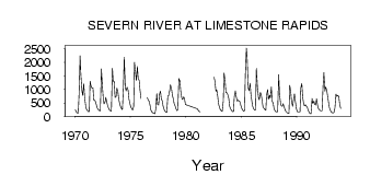
| PointID: | 4322 | Code: | 04CC001 | Latitude (decimal degrees): | 55.37 | Longitude (decimal degrees): | -88.32 | Drainage Area (km2): | 94300.00 | Source: | Hydat | Hydrological Zone: | South and East Hudson Bay | Name: | SEVERN RIVER AT LIMESTONE RAPIDS |
|---|
| Download | |
|---|---|
| Site Descriptor Information | Site Time Series Data |
| Link to all available data | |
| ID | Year | Jan | Feb | Mar | Apr | May | Jun | Jul | Aug | Sep | Oct | Nov | Dec |
|---|---|---|---|---|---|---|---|---|---|---|---|---|---|
| 4322 | 1970 | 249.00 | 168.00 | 132.00 | 117.00 | 809.00 | 2250.00 | 1540.00 | 954.00 | 780.00 | 1210.00 | 736.00 | 413.00 |
| 4322 | 1971 | 277.00 | 217.00 | 182.00 | 181.00 | 1300.00 | 1110.00 | 1050.00 | 1060.00 | 605.00 | 602.00 | 533.00 | 392.00 |
| 4322 | 1972 | 299.00 | 244.00 | 213.00 | 203.00 | 1760.00 | 1260.00 | 695.00 | 472.00 | 529.00 | 706.00 | 521.00 | 388.00 |
| 4322 | 1973 | 293.00 | 236.00 | 203.00 | 195.00 | 1780.00 | 1290.00 | 1290.00 | 700.00 | 733.00 | 1050.00 | 913.00 | 649.00 |
| 4322 | 1974 | 468.00 | 358.00 | 284.00 | 259.00 | 1100.00 | 2190.00 | 1090.00 | 949.00 | 1080.00 | 968.00 | 646.00 | 465.00 |
| 4322 | 1975 | 356.00 | 286.00 | 238.00 | 375.00 | 2000.00 | 1620.00 | 1320.00 | 1850.00 | 1410.00 | 1330.00 | 988.00 | 665.00 |
| 4322 | 1976 | 699.00 | 582.00 | 565.00 | 376.00 | 215.00 | 158.00 | ||||||
| 4322 | 1977 | 130.00 | 114.00 | 102.00 | 278.00 | 848.00 | 436.00 | 422.00 | 817.00 | 938.00 | 650.00 | 565.00 | 380.00 |
| 4322 | 1978 | 255.00 | 195.00 | 163.00 | 153.00 | 766.00 | 773.00 | 959.00 | 1170.00 | 1020.00 | 808.00 | 636.00 | 475.00 |
| 4322 | 1979 | 378.00 | 283.00 | 216.00 | 237.00 | 1400.00 | 1310.00 | 947.00 | 683.00 | 629.00 | 721.00 | 686.00 | 439.00 |
| 4322 | 1981 | 286.00 | 229.00 | 191.00 | 168.00 | 1110.00 | |||||||
| 4322 | 1982 | 1450.00 | 1310.00 | 934.00 | 987.00 | 728.00 | 464.00 | ||||||
| 4322 | 1983 | 325.00 | 243.00 | 199.00 | 187.00 | 555.00 | 1600.00 | 1320.00 | 877.00 | 877.00 | 808.00 | 664.00 | 380.00 |
| 4322 | 1984 | 278.00 | 238.00 | 175.00 | 183.00 | 728.00 | 941.00 | 747.00 | 565.00 | 609.00 | 569.00 | 543.00 | 400.00 |
| 4322 | 1985 | 303.00 | 236.00 | 198.00 | 219.00 | 1530.00 | 2530.00 | 2120.00 | 1050.00 | 957.00 | 1230.00 | 838.00 | 550.00 |
| 4322 | 1986 | 372.00 | 279.00 | 235.00 | 238.00 | 1780.00 | 1100.00 | 700.00 | 617.00 | 888.00 | 836.00 | 582.00 | 367.00 |
| 4322 | 1987 | 292.00 | 256.00 | 232.00 | 804.00 | 994.00 | 630.00 | 785.00 | 670.00 | 1090.00 | 567.00 | 491.00 | 292.00 |
| 4322 | 1988 | 207.00 | 176.00 | 167.00 | 177.00 | 1550.00 | 836.00 | 496.00 | 390.00 | 371.00 | 468.00 | 351.00 | 248.00 |
| 4322 | 1989 | 179.00 | 141.00 | 119.00 | 113.00 | 1150.00 | 903.00 | 549.00 | 371.00 | 596.00 | 841.00 | 586.00 | 302.00 |
| 4322 | 1990 | 184.00 | 155.00 | 155.00 | 156.00 | 1050.00 | 1220.00 | 738.00 | 467.00 | 387.00 | 432.00 | 384.00 | 334.00 |
| 4322 | 1991 | 236.00 | 150.00 | 110.00 | 97.00 | 663.00 | 479.00 | 570.00 | 448.00 | 422.00 | 655.00 | 406.00 | 299.00 |
| 4322 | 1992 | 244.00 | 217.00 | 204.00 | 203.00 | 1150.00 | 1620.00 | 933.00 | 1090.00 | 973.00 | 764.00 | 506.00 | 320.00 |
| 4322 | 1993 | 213.00 | 159.00 | 135.00 | 132.00 | 157.00 | 312.00 | 826.00 | 738.00 | 780.00 | 731.00 | 455.00 | 298.00 |
 Return to R-Arctic Net Home Page