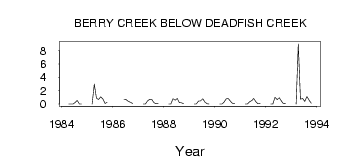
| PointID: | 421 | Code: | 05CH016 | Latitude (decimal degrees): | 50.93 | Longitude (decimal degrees): | -111.76 | Drainage Area (km2): | 2480.00 | Source: | Hydat | Hydrological Zone: | Nelson | Name: | BERRY CREEK BELOW DEADFISH CREEK |
|---|
| Download | |
|---|---|
| Site Descriptor Information | Site Time Series Data |
| Link to all available data | |
| ID | Year | Jan | Feb | Mar | Apr | May | Jun | Jul | Aug | Sep | Oct | Nov | Dec |
|---|---|---|---|---|---|---|---|---|---|---|---|---|---|
| 421 | 1984 | 0.00 | 0.00 | 0.00 | 0.25 | 0.55 | 0.02 | 0.01 | |||||
| 421 | 1985 | 0.00 | 3.00 | 0.86 | 0.68 | 1.10 | 0.78 | 0.08 | 0.25 | ||||
| 421 | 1986 | 0.70 | 0.65 | 0.39 | 0.26 | 0.09 | |||||||
| 421 | 1987 | 0.00 | 0.00 | 0.49 | 0.68 | 0.72 | 0.21 | 0.06 | 0.13 | ||||
| 421 | 1988 | 0.00 | 0.00 | 0.80 | 0.58 | 0.82 | 0.22 | 0.18 | 0.05 | ||||
| 421 | 1989 | 0.00 | 0.00 | 0.45 | 0.48 | 0.79 | 0.31 | 0.04 | 0.02 | ||||
| 421 | 1990 | 0.00 | 0.00 | 0.28 | 0.78 | 0.83 | 0.45 | 0.10 | 0.12 | ||||
| 421 | 1991 | 0.00 | 0.00 | 0.33 | 0.51 | 0.82 | 0.36 | 0.05 | 0.10 | ||||
| 421 | 1992 | 0.00 | 0.00 | 1.03 | 0.67 | 0.93 | 0.45 | 0.06 | 0.09 | ||||
| 421 | 1993 | 0.00 | 9.00 | 0.74 | 0.84 | 0.39 | 1.11 | 0.57 | 0.12 |
 Return to R-Arctic Net Home Page