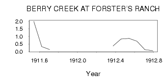
| PointID: | 411 | Code: | 05CH001 | Latitude (decimal degrees): | 50.96 | Longitude (decimal degrees): | -111.75 | Drainage Area (km2): | 2460.00 | Source: | Hydat | Hydrological Zone: | Nelson | Name: | BERRY CREEK AT FORSTER'S RANCH |
|---|
| Download | |
|---|---|
| Site Descriptor Information | Site Time Series Data |
| Link to all available data | |
| ID | Year | Jan | Feb | Mar | Apr | May | Jun | Jul | Aug | Sep | Oct | Nov | Dec |
|---|---|---|---|---|---|---|---|---|---|---|---|---|---|
| 411 | 1911 | 1.99 | 0.33 | 0.14 | |||||||||
| 411 | 1912 | 0.38 | 0.83 | 0.87 | 0.69 | 0.13 | 0.06 |
 Return to R-Arctic Net Home Page