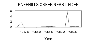
| PointID: | 400 | Code: | 05CE016 | Latitude (decimal degrees): | 51.59 | Longitude (decimal degrees): | -113.51 | Drainage Area (km2): | 642.00 | Source: | Hydat | Hydrological Zone: | Nelson | Name: | KNEEHILLS CREEK NEAR LINDEN |
|---|
| Download | |
|---|---|
| Site Descriptor Information | Site Time Series Data |
| Link to all available data | |
| ID | Year | Jan | Feb | Mar | Apr | May | Jun | Jul | Aug | Sep | Oct | Nov | Dec |
|---|---|---|---|---|---|---|---|---|---|---|---|---|---|
| 400 | 1967 | 0.00 | 1.00 | 1.82 | 0.14 | ||||||||
| 400 | 1968 | 0.00 | 0.00 | 0.01 | 0.03 | 0.08 | 0.08 | 5.0e-03 | 0.01 | ||||
| 400 | 1969 | 0.00 | 6.00 | 0.21 | 0.04 | 0.02 | 3.0e-03 | 0.03 | 0.01 |
 Return to R-Arctic Net Home Page