ROSEBUD RIVER AT BEYNON
Nelson
| PointID: | 388 |
Code: | 05CE003 |
Latitude (decimal degrees): | 51.33 |
Longitude (decimal degrees): | -112.78 |
Drainage Area (km2): | 3990.00 |
Source: | Hydat |
Hydrological Zone: | Nelson |
Name: | ROSEBUD RIVER AT BEYNON |
Field Definitions
Site Time Series Plot:
Site Data File:
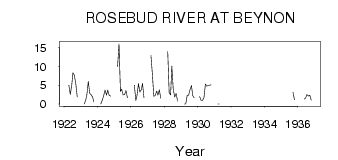
(Units: m3/s)
| ID | Year | Jan | Feb | Mar | Apr | May | Jun | Jul | Aug | Sep | Oct | Nov | Dec |
|---|
| 388 | 1922 | | | | 5.00 | 2.56 | 4.97 | 8.34 | 7.61 | 5.38 | 1.85 | | |
| 388 | 1923 | | | 0.00 | 1.00 | 2.47 | 6.01 | 2.90 | 2.47 | 1.90 | 0.59 | | |
| 388 | 1924 | | | 0.00 | 1.00 | 2.17 | 3.75 | 2.37 | 3.70 | 2.34 | 2.10 | | |
| 388 | 1925 | | | 10.00 | 16.00 | 3.35 | 4.00 | 2.42 | 2.48 | 3.62 | 1.66 | | |
| 388 | 1926 | | | 5.00 | 1.00 | 2.28 | 5.47 | 3.21 | 3.82 | 5.54 | 1.69 | | |
| 388 | 1927 | | | 13.00 | 8.00 | 2.08 | 2.32 | 3.45 | 2.36 | 3.80 | 1.57 | | |
| 388 | 1928 | | | 14.00 | 3.00 | 2.45 | 10.10 | 3.92 | 1.88 | 2.81 | 0.81 | | |
| 388 | 1929 | | | 0.00 | 0.00 | 2.24 | 2.39 | 3.86 | 4.96 | 2.28 | 1.70 | | |
| 388 | 1930 | | 2.00 | 1.00 | 1.00 | 1.72 | 5.34 | 4.81 | 4.85 | 4.98 | 5.10 | | |
| 388 | 1931 | | | 0.00 | 0.00 | | | | | | | | |
| 388 | 1935 | | | | | | | | | 3.12 | 1.15 | | |
| 388 | 1936 | | | 11.00 | | 1.37 | 1.58 | 2.48 | 2.15 | 2.33 | 1.01 | | |
All data provided by Environment Canada is copyright and its use is
restricted to non-commercial education and research purposes. Resale of
this data is prohibited. Any user of this data is required to give full
credit to Environment Canada as the source of the Canadian data. This
includes any research leading to a publication.
 Return to R-Arctic Net Home Page