| PointID: | 382 | Code: | 05CD004 | Latitude (decimal degrees): | 52.30 | Longitude (decimal degrees): | -113.06 | Drainage Area (km2): | 15100.00 | Source: | Hydat | Hydrological Zone: | Nelson | Name: | RED DEER RIVER NEAR NEVIS |
|---|
| Download | |
|---|---|
| Site Descriptor Information | Site Time Series Data |
| Link to all available data | |
| ID | Year | Jan | Feb | Mar | Apr | May | Jun | Jul | Aug | Sep | Oct | Nov | Dec |
|---|---|---|---|---|---|---|---|---|---|---|---|---|---|
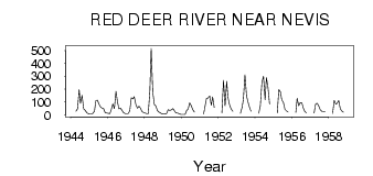
| 382 | 1944 | 30.00 | 46.90 | 197.00 | 89.80 | 151.00 | 48.00 | 34.50 | 17.00 | 10.00 | |||
| 382 | 1945 | 8.00 | 8.00 | 12.00 | 32.00 | 110.00 | 115.00 | 85.30 | 62.00 | 52.10 | 49.40 | 19.00 | 14.00 |
| 382 | 1946 | 13.00 | 11.00 | 40.00 | 84.00 | 50.00 | 183.00 | 97.70 | 47.30 | 53.50 | 34.80 | 17.00 | 11.00 |
| 382 | 1947 | 11.00 | 10.00 | 31.00 | 133.00 | 125.00 | 141.00 | 82.80 | 52.50 | 67.50 | 52.20 | 28.00 | 18.00 |
| 382 | 1948 | 14.00 | 11.00 | 10.00 | 187.00 | 516.00 | 176.00 | 80.70 | 70.60 | 35.10 | 23.90 | 16.00 | 7.00 |
| 382 | 1949 | 8.00 | 7.00 | 10.00 | 42.00 | 34.90 | 39.40 | 49.50 | 34.40 | 17.80 | 15.80 | 11.00 | 4.00 |
| 382 | 1950 | 4.00 | 5.00 | 5.00 | 36.00 | 48.00 | 94.70 | 74.60 | 42.20 | 23.70 | |||
| 382 | 1951 | 8.00 | 63.00 | 129.00 | 131.00 | 148.00 | 76.40 | 140.00 | 57.60 | ||||
| 382 | 1952 | 17.00 | 268.00 | 70.10 | 260.00 | 135.00 | 78.90 | 45.40 | 29.00 | ||||
| 382 | 1953 | 12.00 | 57.00 | 120.00 | 311.00 | 147.00 | 96.80 | 54.60 | 28.30 | ||||
| 382 | 1954 | 13.00 | 70.00 | 250.00 | 301.00 | 116.00 | 289.00 | 213.00 | 83.30 | ||||
| 382 | 1955 | 14.00 | 197.00 | 179.00 | 116.00 | 99.00 | 43.10 | 31.00 | 23.90 | ||||
| 382 | 1956 | 19.00 | 129.00 | 72.20 | 97.50 | 93.40 | 50.00 | 28.10 | 17.40 | ||||
| 382 | 1957 | 14.00 | 87.00 | 90.20 | 67.30 | 37.40 | 30.00 | 26.30 | 24.20 | ||||
| 382 | 1958 | 11.00 | 112.00 | 84.70 | 91.40 | 113.00 | 48.50 | 32.20 | 20.10 |
 Return to R-Arctic Net Home Page