| PointID: | 379 | Code: | 05CC011 | Latitude (decimal degrees): | 52.26 | Longitude (decimal degrees): | -113.79 | Drainage Area (km2): | 494.00 | Source: | Hydat | Hydrological Zone: | Nelson | Name: | WASKASOO CREEK AT RED DEER |
|---|
| Download | |
|---|---|
| Site Descriptor Information | Site Time Series Data |
| Link to all available data | |
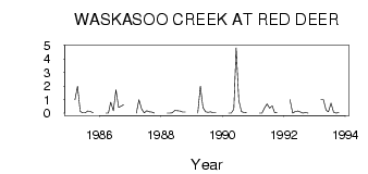
| ID | Year | Jan | Feb | Mar | Apr | May | Jun | Jul | Aug | Sep | Oct | Nov | Dec |
|---|---|---|---|---|---|---|---|---|---|---|---|---|---|
| 379 | 1985 | 1.00 | 2.00 | 0.14 | 0.02 | 0.02 | 0.16 | 0.13 | 0.02 | ||||
| 379 | 1986 | 0.00 | 0.00 | 0.82 | 0.18 | 1.72 | 0.43 | 0.51 | 0.63 | ||||
| 379 | 1987 | 0.00 | 1.00 | 0.31 | 0.03 | 0.18 | 0.10 | 0.09 | 0.01 | ||||
| 379 | 1988 | 0.00 | 0.00 | 0.02 | 0.20 | 0.18 | 0.17 | 0.08 | 0.08 | ||||
| 379 | 1989 | 0.00 | 2.00 | 0.42 | 0.10 | 0.07 | 0.10 | 0.02 | 0.02 | ||||
| 379 | 1990 | 0.00 | 0.00 | 0.30 | 4.84 | 0.96 | 0.13 | 0.04 | 0.02 | ||||
| 379 | 1991 | 0.00 | 0.00 | 0.38 | 0.68 | 0.38 | 0.54 | 0.05 | 0.03 | ||||
| 379 | 1992 | 1.00 | 0.00 | 0.13 | 0.17 | 0.08 | 0.01 | 0.04 | 0.01 | ||||
| 379 | 1993 | 1.00 | 1.00 | 0.22 | 0.10 | 0.74 | 0.07 | 0.01 | 0.05 |
 Return to R-Arctic Net Home Page