| PointID: | 370 | Code: | 05CB005 | Latitude (decimal degrees): | 51.36 | Longitude (decimal degrees): | -114.43 | Drainage Area (km2): | 45.29 | Source: | Hydat | Hydrological Zone: | Nelson | Name: | BEAVERDAM CREEK NEAR COCHRANE |
|---|
| Download | |
|---|---|
| Site Descriptor Information | Site Time Series Data |
| Link to all available data | |
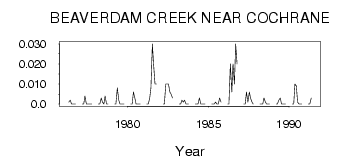
| ID | Year | Jan | Feb | Mar | Apr | May | Jun | Jul | Aug | Sep | Oct | Nov | Dec |
|---|---|---|---|---|---|---|---|---|---|---|---|---|---|
| 370 | 1976 | 1.0e-03 | 2.0e-03 | 0.00 | 0.00 | 0.00 | 0.00 | ||||||
| 370 | 1977 | 0.00 | 0.00 | 4.0e-03 | 0.00 | 0.00 | 0.00 | 0.00 | 0.00 | ||||
| 370 | 1978 | 0.00 | 0.00 | 3.0e-03 | 1.0e-03 | 0.00 | 4.0e-03 | 0.00 | 0.00 | ||||
| 370 | 1979 | 0.00 | 0.00 | 8.0e-03 | 2.0e-03 | 0.00 | 0.00 | 0.00 | 0.00 | ||||
| 370 | 1980 | 0.00 | 0.00 | 6.0e-03 | 3.0e-03 | 0.00 | 0.00 | 0.00 | 0.00 | ||||
| 370 | 1981 | 0.00 | 0.00 | 3.0e-03 | 8.0e-03 | 0.03 | 0.02 | 0.01 | 0.01 | ||||
| 370 | 1982 | 0.00 | 0.00 | 0.01 | 0.01 | 0.01 | 6.0e-03 | 5.0e-03 | 3.0e-03 | ||||
| 370 | 1983 | 0.00 | 0.00 | 2.0e-03 | 1.0e-03 | 2.0e-03 | 0.00 | 0.00 | 0.00 | ||||
| 370 | 1984 | 0.00 | 0.00 | 0.00 | 3.0e-03 | 0.00 | 0.00 | 0.00 | 0.00 | ||||
| 370 | 1985 | 0.00 | 0.00 | 0.00 | 1.0e-03 | 0.00 | 0.00 | 3.0e-03 | 1.0e-03 | ||||
| 370 | 1986 | 0.00 | 0.00 | 0.02 | 6.0e-03 | 0.02 | 0.01 | 0.03 | 0.02 | ||||
| 370 | 1987 | 0.00 | 0.00 | 6.0e-03 | 1.0e-03 | 6.0e-03 | 3.0e-03 | 1.0e-03 | 0.00 | ||||
| 370 | 1988 | 0.00 | 0.00 | 0.00 | 3.0e-03 | 1.0e-03 | 0.00 | 0.00 | 0.00 | ||||
| 370 | 1989 | 0.00 | 0.00 | 2.0e-03 | 3.0e-03 | 0.00 | 0.00 | 0.00 | 0.00 | ||||
| 370 | 1990 | 0.00 | 0.00 | 0.01 | 9.0e-03 | 1.0e-03 | 0.00 | 0.00 | 0.00 | ||||
| 370 | 1991 | 0.00 | 0.00 | 3.0e-03 |
 Return to R-Arctic Net Home Page