| PointID: | 3696 | Code: | 10VC001 | Latitude (decimal degrees): | 74.84 | Longitude (decimal degrees): | -95.05 | Drainage Area (km2): | 448.00 | Source: | Hydat | Hydrological Zone: | Mackenzie | Name: | ALLEN RIVER NEAR THE MOUTH |
|---|
| Download | |
|---|---|
| Site Descriptor Information | Site Time Series Data |
| Link to all available data | |
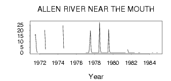
| ID | Year | Jan | Feb | Mar | Apr | May | Jun | Jul | Aug | Sep | Oct | Nov | Dec |
|---|---|---|---|---|---|---|---|---|---|---|---|---|---|
| 3696 | 1971 | 15.70 | 16.40 | 3.55 | 0.01 | ||||||||
| 3696 | 1972 | 20.40 | 3.05 | ||||||||||
| 3696 | 1973 | 5.76 | |||||||||||
| 3696 | 1974 | 24.50 | 4.00 | ||||||||||
| 3696 | 1975 | 5.20 | |||||||||||
| 3696 | 1977 | 0.00 | 0.00 | 0.00 | 0.00 | 0.00 | 6.99 | 19.90 | 1.77 | 0.02 | 0.00 | 0.00 | 0.00 |
| 3696 | 1978 | 0.00 | 0.00 | 0.00 | 0.00 | 0.00 | 0.00 | 27.40 | 2.76 | 0.04 | 0.00 | 0.00 | 0.00 |
| 3696 | 1979 | 0.00 | 0.00 | 0.00 | 0.00 | 0.00 | 0.00 | 21.00 | 1.23 | 0.01 | 0.00 | 0.00 | 0.00 |
| 3696 | 1981 | 0.00 | 0.00 | 0.00 | 0.00 | 0.00 | 2.85 | 0.01 | 0.00 | 0.00 | 0.00 | ||
| 3696 | 1982 | 0.00 | 0.00 | 0.00 | 0.00 | 0.00 | 0.00 | 0.00 | 0.00 | ||||
| 3696 | 1983 | 0.00 | |||||||||||
| 3696 | 1984 | 0.00 | 0.00 | 0.00 | 0.00 |
 Return to R-Arctic Net Home Page