| PointID: | 3694 | Code: | 10UH001 | Latitude (decimal degrees): | 63.76 | Longitude (decimal degrees): | -68.58 | Drainage Area (km2): | 2980.00 | Source: | Hydat | Hydrological Zone: | Mackenzie | Name: | SYLVIA GRINNELL RIVER NEAR IQALUIT |
|---|
| Download | |
|---|---|
| Site Descriptor Information | Site Time Series Data |
| Link to all available data | |
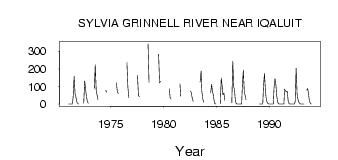
| ID | Year | Jan | Feb | Mar | Apr | May | Jun | Jul | Aug | Sep | Oct | Nov | Dec |
|---|---|---|---|---|---|---|---|---|---|---|---|---|---|
| 3694 | 1971 | 1.00 | 0.00 | 0.00 | 0.00 | 0.03 | 42.20 | 158.00 | 57.20 | 42.50 | 13.10 | 4.00 | 1.00 |
| 3694 | 1972 | 4.40 | 132.00 | 79.60 | 48.60 | 13.40 | 5.00 | ||||||
| 3694 | 1973 | 89.30 | 223.00 | 76.60 | 56.00 | 26.10 | |||||||
| 3694 | 1974 | 78.70 | 67.90 | ||||||||||
| 3694 | 1975 | 120.00 | 71.20 | 59.30 | |||||||||
| 3694 | 1976 | 236.00 | 95.70 | 35.50 | |||||||||
| 3694 | 1977 | 164.00 | 48.30 | 41.90 | |||||||||
| 3694 | 1978 | 342.00 | 123.00 | ||||||||||
| 3694 | 1979 | 283.00 | 121.00 | 130.00 | |||||||||
| 3694 | 1980 | 86.20 | 36.20 | 28.90 | |||||||||
| 3694 | 1981 | 115.00 | 44.80 | ||||||||||
| 3694 | 1982 | 73.80 | 66.20 | 33.90 | 15.50 | ||||||||
| 3694 | 1983 | 126.00 | 188.00 | 74.50 | 28.80 | 9.99 | |||||||
| 3694 | 1984 | 64.50 | 112.00 | 74.60 | 50.60 | 12.40 | 2.00 | 0.00 | |||||
| 3694 | 1985 | 1.52 | 148.00 | 101.00 | 53.80 | 63.50 | 21.20 | ||||||
| 3694 | 1986 | 7.32 | 243.00 | 96.00 | 84.50 | 15.10 | 2.00 | 0.00 | |||||
| 3694 | 1987 | 0.00 | 0.00 | 0.00 | 0.00 | 0.00 | 105.00 | 191.00 | 71.40 | 52.50 | 24.60 | ||
| 3694 | 1989 | 0.00 | 0.00 | 0.00 | 0.00 | 0.00 | 101.00 | 174.00 | 78.00 | 33.90 | 10.30 | 3.00 | 1.00 |
| 3694 | 1990 | 0.00 | 0.00 | 0.00 | 0.00 | 0.04 | 93.80 | 145.00 | 106.00 | 49.00 | 10.50 | 2.00 | 0.00 |
| 3694 | 1991 | 0.00 | 0.00 | 0.00 | 0.00 | 0.01 | 85.70 | 74.00 | 68.90 | 72.20 | 17.30 | 2.00 | 1.00 |
| 3694 | 1992 | 0.00 | 0.00 | 0.00 | 0.00 | 0.00 | 13.70 | 204.00 | 58.90 | 29.80 | 11.40 | 4.00 | 1.00 |
| 3694 | 1993 | 0.00 | 0.00 | 0.00 | 0.00 | 80.20 | 87.60 | 56.20 | 19.10 | 5.00 | 1.00 |
 Return to R-Arctic Net Home Page