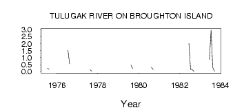
| PointID: | 3692 | Code: | 10UE001 | Latitude (decimal degrees): | 67.56 | Longitude (decimal degrees): | -63.98 | Drainage Area (km2): | 27.38 | Source: | Hydat | Hydrological Zone: | Mackenzie | Name: | TULUGAK RIVER ON BROUGHTON ISLAND |
|---|
| Download | |
|---|---|
| Site Descriptor Information | Site Time Series Data |
| Link to all available data | |
| ID | Year | Jan | Feb | Mar | Apr | May | Jun | Jul | Aug | Sep | Oct | Nov | Dec |
|---|---|---|---|---|---|---|---|---|---|---|---|---|---|
| 3692 | 1975 | 0.24 | 0.18 | ||||||||||
| 3692 | 1976 | 1.52 | 0.55 | ||||||||||
| 3692 | 1977 | 0.13 | 0.04 | ||||||||||
| 3692 | 1979 | 0.46 | 0.22 | ||||||||||
| 3692 | 1980 | 0.31 | 0.16 | ||||||||||
| 3692 | 1981 | 0.34 | |||||||||||
| 3692 | 1982 | 2.01 | 0.17 | 0.14 | 0.01 | ||||||||
| 3692 | 1983 | 0.87 | 2.95 | 0.29 | 0.03 |
 Return to R-Arctic Net Home Page