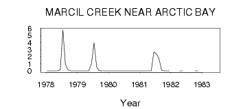
| PointID: | 3691 | Code: | 10UB001 | Latitude (decimal degrees): | 72.99 | Longitude (decimal degrees): | -84.98 | Drainage Area (km2): | 139.00 | Source: | Hydat | Hydrological Zone: | Mackenzie | Name: | MARCIL CREEK NEAR ARCTIC BAY |
|---|
| Download | |
|---|---|
| Site Descriptor Information | Site Time Series Data |
| Link to all available data | |
| ID | Year | Jan | Feb | Mar | Apr | May | Jun | Jul | Aug | Sep | Oct | Nov | Dec |
|---|---|---|---|---|---|---|---|---|---|---|---|---|---|
| 3691 | 1978 | 0.00 | 0.00 | 0.00 | 0.00 | 0.00 | 0.15 | 5.80 | 0.96 | 0.15 | 0.00 | 0.00 | 0.00 |
| 3691 | 1979 | 0.00 | 0.00 | 0.00 | 0.00 | 0.00 | 0.98 | 3.98 | 0.54 | 0.03 | 0.00 | 0.00 | 0.00 |
| 3691 | 1981 | 0.00 | 0.00 | 0.00 | 0.00 | 0.00 | 2.66 | 2.39 | 1.76 | 0.11 | 0.00 | 0.00 | 0.00 |
| 3691 | 1982 | 0.00 | 0.00 | 0.00 | 0.00 | ||||||||
| 3691 | 1983 | 0.00 |
 Return to R-Arctic Net Home Page