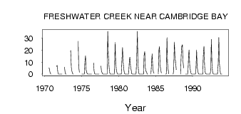
| PointID: | 3689 | Code: | 10TF001 | Latitude (decimal degrees): | 69.13 | Longitude (decimal degrees): | -104.99 | Drainage Area (km2): | 1490.00 | Source: | Hydat | Hydrological Zone: | Mackenzie | Name: | FRESHWATER CREEK NEAR CAMBRIDGE BAY |
|---|
| Download | |
|---|---|
| Site Descriptor Information | Site Time Series Data |
| Link to all available data | |
| ID | Year | Jan | Feb | Mar | Apr | May | Jun | Jul | Aug | Sep | Oct | Nov | Dec |
|---|---|---|---|---|---|---|---|---|---|---|---|---|---|
| 3689 | 1970 | 5.31 | 2.46 | 0.63 | 0.00 | ||||||||
| 3689 | 1971 | 6.38 | 7.39 | 1.80 | 0.00 | 0.00 | |||||||
| 3689 | 1972 | 0.00 | 0.00 | 0.00 | 0.00 | 0.00 | 5.97 | 1.07 | 0.00 | 0.00 | |||
| 3689 | 1973 | 19.80 | 5.67 | 2.64 | 0.65 | 0.00 | |||||||
| 3689 | 1974 | 27.60 | 6.79 | 1.47 | |||||||||
| 3689 | 1975 | 0.00 | 0.00 | 0.00 | 0.00 | 0.00 | 10.00 | 15.40 | 3.87 | 1.28 | 0.21 | 0.00 | 0.00 |
| 3689 | 1976 | 0.00 | 0.00 | 0.00 | 0.00 | 0.00 | 9.42 | 2.65 | 0.19 | 0.00 | 0.00 | ||
| 3689 | 1977 | 0.00 | 0.00 | 0.00 | 0.00 | 0.00 | 6.77 | 2.69 | 0.98 | 0.00 | 0.00 | ||
| 3689 | 1978 | 0.00 | 0.00 | 0.00 | 0.00 | 0.00 | 0.01 | 35.90 | 17.20 | 6.88 | 1.72 | 0.00 | 0.00 |
| 3689 | 1979 | 0.00 | 0.00 | 0.00 | 0.00 | 0.00 | 0.05 | 26.50 | 10.30 | 3.59 | 1.00 | 0.00 | 0.00 |
| 3689 | 1980 | 0.00 | 0.00 | 0.00 | 0.00 | 0.00 | 10.10 | 22.20 | 9.89 | 4.79 | 0.81 | 0.00 | 0.00 |
| 3689 | 1981 | 0.00 | 0.00 | 0.00 | 0.00 | 0.00 | 11.50 | 14.20 | 6.44 | 3.19 | 0.35 | 0.00 | 0.00 |
| 3689 | 1982 | 0.00 | 0.00 | 0.00 | 0.00 | 0.00 | 12.80 | 35.90 | 9.32 | 1.82 | 0.07 | 0.00 | 0.00 |
| 3689 | 1983 | 0.00 | 0.00 | 0.00 | 0.00 | 0.00 | 15.60 | 18.90 | 5.61 | 2.55 | 1.77 | 0.00 | 0.00 |
| 3689 | 1984 | 0.00 | 9.82 | 16.90 | 5.45 | 2.13 | 0.65 | ||||||
| 3689 | 1985 | 0.00 | 20.30 | 23.10 | 7.01 | 3.31 | 0.94 | ||||||
| 3689 | 1986 | 0.00 | 0.23 | 30.50 | 9.10 | 3.57 | 0.23 | ||||||
| 3689 | 1987 | 0.00 | 3.13 | 26.90 | 12.60 | 11.00 | 3.75 | ||||||
| 3689 | 1988 | 0.00 | 16.00 | 23.10 | 24.70 | 11.50 | 5.24 | ||||||
| 3689 | 1989 | 0.00 | 0.00 | 0.00 | 0.00 | 0.00 | 15.70 | 20.20 | 7.03 | 3.01 | 0.72 | 0.00 | 0.00 |
| 3689 | 1990 | 0.00 | 0.00 | 0.00 | 0.00 | 0.00 | 3.93 | 20.30 | 6.37 | 2.46 | 0.25 | 0.00 | 0.00 |
| 3689 | 1991 | 0.00 | 0.00 | 0.00 | 0.00 | 0.00 | 15.20 | 23.30 | 6.43 | 1.69 | 0.30 | 0.00 | 0.00 |
| 3689 | 1992 | 0.00 | 0.00 | 0.00 | 0.00 | 0.00 | 3.55 | 29.10 | 7.79 | 2.40 | 0.15 | 0.00 | 0.00 |
| 3689 | 1993 | 0.00 | 0.00 | 0.00 | 0.00 | 0.00 | 8.30 | 30.70 | 9.53 | 3.39 | 0.06 | 0.00 | 0.00 |
 Return to R-Arctic Net Home Page