| PointID: | 3685 | Code: | 10RA002 | Latitude (decimal degrees): | 65.01 | Longitude (decimal degrees): | -104.49 | Drainage Area (km2): | 14500.00 | Source: | Hydat | Hydrological Zone: | Mackenzie | Name: | BAILLIE RIVER NEAR THE MOUTH |
|---|
| Download | |
|---|---|
| Site Descriptor Information | Site Time Series Data |
| Link to all available data | |
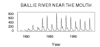
| ID | Year | Jan | Feb | Mar | Apr | May | Jun | Jul | Aug | Sep | Oct | Nov | Dec |
|---|---|---|---|---|---|---|---|---|---|---|---|---|---|
| 3685 | 1978 | 15.00 | 5.00 | 1.00 | |||||||||
| 3685 | 1979 | 0.00 | 0.00 | 0.00 | 0.00 | 41.60 | 26.80 | 13.40 | 5.00 | 1.00 | |||
| 3685 | 1980 | 0.00 | 0.00 | 0.00 | 0.00 | 12.10 | 102.00 | 45.70 | 21.80 | 49.90 | 8.33 | 1.00 | 0.00 |
| 3685 | 1981 | 0.00 | 0.00 | 0.00 | 0.00 | 141.00 | 263.00 | 121.00 | 41.50 | 34.80 | 25.60 | 5.00 | 0.00 |
| 3685 | 1982 | 0.00 | 0.00 | 0.00 | 0.00 | 0.59 | 170.00 | 108.00 | 60.30 | 121.00 | 45.40 | 11.00 | 5.00 |
| 3685 | 1983 | 0.00 | 0.00 | 0.00 | 0.00 | 1.10 | 607.00 | 150.00 | 195.00 | 158.00 | 79.10 | 16.00 | 2.00 |
| 3685 | 1984 | 0.00 | 0.00 | 0.00 | 0.00 | 147.00 | 707.00 | 122.00 | 91.10 | 76.30 | 59.00 | 19.00 | 0.00 |
| 3685 | 1985 | 0.00 | 0.00 | 0.00 | 0.00 | 4.95 | 304.00 | 139.00 | 133.00 | 85.80 | 25.00 | 1.00 | 0.00 |
| 3685 | 1986 | 0.00 | 0.00 | 0.00 | 0.00 | 1.64 | 837.00 | 171.00 | 67.10 | 96.10 | 45.60 | 2.00 | 0.00 |
| 3685 | 1987 | 0.00 | 0.00 | 0.00 | 0.00 | 1.64 | 607.00 | 248.00 | 111.00 | 185.00 | 85.60 | 28.00 | 9.00 |
| 3685 | 1988 | 3.00 | 0.00 | 0.00 | 1.00 | 5.69 | 716.00 | 223.00 | 84.60 | 124.00 | 122.00 | 51.00 | 14.00 |
| 3685 | 1989 | 4.00 | 2.00 | 1.00 | 1.00 | 3.13 | 655.00 | 123.00 | 94.90 | 85.40 | 65.30 | 23.00 | 8.00 |
| 3685 | 1990 | 2.00 | 1.00 | 0.00 | 0.00 | 2.22 | 444.00 | 238.00 | 98.30 | 156.00 | 121.00 | 41.00 | 12.00 |
| 3685 | 1991 | 3.00 | 0.00 | 0.00 | 0.00 | 15.20 | 555.00 | 126.00 | 71.20 | 66.80 | 53.90 | 13.00 | 5.00 |
| 3685 | 1992 | 3.00 | 1.00 | 0.00 | 0.00 | 3.15 | 451.00 | 143.00 | 43.40 | 37.90 | 25.90 | 11.00 | 6.00 |
| 3685 | 1993 | 2.00 | 1.00 | 0.00 | 0.00 | 1.27 | 591.00 | 153.00 | 111.00 | 58.90 | 29.90 | 12.00 | 5.00 |
 Return to R-Arctic Net Home Page