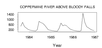
| PointID: | 3678 | Code: | 10PC003 | Latitude (decimal degrees): | 67.74 | Longitude (decimal degrees): | -115.37 | Drainage Area (km2): | 50700.00 | Source: | Hydat | Hydrological Zone: | Mackenzie | Name: | COPPERMINE RIVER ABOVE BLOODY FALLS |
|---|
| Download | |
|---|---|
| Site Descriptor Information | Site Time Series Data |
| Link to all available data | |
| ID | Year | Jan | Feb | Mar | Apr | May | Jun | Jul | Aug | Sep | Oct | Nov | Dec |
|---|---|---|---|---|---|---|---|---|---|---|---|---|---|
| 3678 | 1983 | 469.00 | 775.00 | 439.00 | 325.00 | 216.00 | |||||||
| 3678 | 1984 | 159.00 | 133.00 | 112.00 | 90.00 | 182.00 | 856.00 | 754.00 | 700.00 | 565.00 | 384.00 | 189.00 | 152.00 |
| 3678 | 1985 | 124.00 | 104.00 | 87.00 | 72.00 | 311.00 | 711.00 | 500.00 | 561.00 | 513.00 | 368.00 | 244.00 | 180.00 |
| 3678 | 1986 | 136.00 | 108.00 | 89.00 | 72.00 | 115.00 | 1500.00 | 773.00 | 432.00 | 339.00 | 245.00 | 164.00 | 131.00 |
 Return to R-Arctic Net Home Page