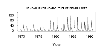
| PointID: | 3676 | Code: | 10PC001 | Latitude (decimal degrees): | 67.21 | Longitude (decimal degrees): | -116.57 | Drainage Area (km2): | 2790.00 | Source: | Hydat | Hydrological Zone: | Mackenzie | Name: | KENDALL RIVER NEAR OUTLET OF DISMAL LAKES |
|---|
| Download | |
|---|---|
| Site Descriptor Information | Site Time Series Data |
| Link to all available data | |
| ID | Year | Jan | Feb | Mar | Apr | May | Jun | Jul | Aug | Sep | Oct | Nov | Dec |
|---|---|---|---|---|---|---|---|---|---|---|---|---|---|
| 3676 | 1969 | 11.50 | 3.00 | 1.00 | |||||||||
| 3676 | 1970 | 0.00 | 0.00 | 17.80 | 47.80 | 18.00 | 6.00 | 1.00 | |||||
| 3676 | 1971 | 33.00 | 16.00 | 19.10 | 11.10 | 1.00 | 0.00 | ||||||
| 3676 | 1972 | 10.50 | 3.12 | 0.42 | 0.00 | ||||||||
| 3676 | 1973 | 0.00 | 0.00 | 0.00 | 0.00 | 18.50 | 46.80 | 25.20 | 11.40 | 1.00 | 0.00 | ||
| 3676 | 1974 | 0.00 | 0.00 | 0.00 | 0.00 | 31.90 | 11.90 | 5.42 | 0.27 | 0.00 | 0.00 | ||
| 3676 | 1975 | 0.00 | 0.00 | 0.00 | 0.00 | 30.20 | 7.84 | 4.30 | 0.90 | 0.00 | 0.00 | ||
| 3676 | 1976 | 0.00 | 0.00 | 0.00 | 0.00 | 0.00 | 28.20 | 16.40 | 8.69 | 4.85 | 0.00 | 0.00 | |
| 3676 | 1977 | 0.00 | 0.00 | 0.00 | 0.00 | 19.30 | 3.00 | 0.00 | |||||
| 3676 | 1978 | 0.00 | 0.00 | 0.00 | 0.00 | 0.00 | 79.50 | 65.80 | 13.10 | 3.68 | 0.79 | 0.00 | 0.00 |
| 3676 | 1979 | 0.00 | 0.00 | 0.00 | 0.00 | 7.12 | 66.40 | 28.30 | 8.62 | 4.61 | 1.32 | 0.00 | 0.00 |
| 3676 | 1980 | 0.00 | 0.00 | 0.00 | 0.00 | 3.11 | 106.00 | 31.90 | 12.50 | 8.85 | 3.27 | 0.00 | 0.00 |
| 3676 | 1981 | 14.50 | 16.50 | 11.00 | 1.00 | 0.00 | |||||||
| 3676 | 1982 | 0.00 | 0.00 | 0.00 | 0.00 | 0.55 | 137.00 | 51.20 | 18.80 | 10.20 | 2.94 | 0.00 | 0.00 |
| 3676 | 1983 | 0.00 | 0.00 | 0.00 | 0.00 | 0.01 | 107.00 | 42.40 | 19.20 | 46.20 | 19.50 | 1.00 | 0.00 |
| 3676 | 1984 | 0.00 | 0.00 | 0.00 | 0.00 | 23.80 | 115.00 | 24.30 | 22.80 | 17.30 | 4.92 | 0.00 | 0.00 |
| 3676 | 1985 | 4.80 | 79.60 | 28.30 | 19.50 | 16.40 | 4.83 | ||||||
| 3676 | 1986 | 0.00 | 0.00 | 0.00 | 0.00 | 0.00 | 103.00 | 66.70 | 13.80 | 6.52 | 0.62 | 0.00 | 0.00 |
| 3676 | 1987 | 0.00 | 0.00 | 0.00 | 0.00 | 0.00 | 94.50 | 52.80 | 15.40 | 18.70 | 6.43 | 0.00 | 0.00 |
| 3676 | 1988 | 0.00 | 0.00 | 0.00 | 0.00 | 3.0e-03 | 68.70 | 21.40 | 11.20 | 42.40 | 11.20 | 0.00 | 0.00 |
| 3676 | 1989 | 0.00 | 0.00 | 0.00 | 0.00 | 5.0e-03 | 107.00 | 43.00 | 14.80 | 9.70 | 3.53 | 0.00 | 0.00 |
| 3676 | 1990 | 0.00 | 0.00 | 0.00 | 0.00 | 0.59 | 80.70 | 41.10 | 11.60 | 10.90 | 7.91 | 0.00 | 0.00 |
 Return to R-Arctic Net Home Page