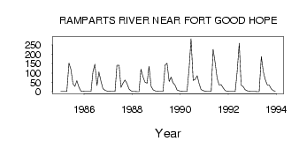
| PointID: | 3649 | Code: | 10KD004 | Latitude (decimal degrees): | 66.11 | Longitude (decimal degrees): | -129.27 | Drainage Area (km2): | 7410.00 | Source: | Hydat | Hydrological Zone: | Mackenzie | Name: | RAMPARTS RIVER NEAR FORT GOOD HOPE |
|---|
| Download | |
|---|---|
| Site Descriptor Information | Site Time Series Data |
| Link to all available data | |
| ID | Year | Jan | Feb | Mar | Apr | May | Jun | Jul | Aug | Sep | Oct | Nov | Dec |
|---|---|---|---|---|---|---|---|---|---|---|---|---|---|
| 3649 | 1985 | 2.00 | 2.00 | 1.00 | 1.00 | 153.00 | 120.00 | 41.10 | 29.00 | 58.60 | 23.70 | 4.00 | 3.00 |
| 3649 | 1986 | 2.00 | 1.00 | 1.00 | 1.00 | 107.00 | 147.00 | 33.50 | 105.00 | 54.70 | 16.50 | 7.00 | 4.00 |
| 3649 | 1987 | 3.00 | 2.00 | 1.00 | 1.00 | 141.00 | 142.00 | 23.30 | 46.50 | 62.10 | 44.20 | 14.00 | 5.00 |
| 3649 | 1988 | 2.00 | 1.00 | 0.00 | 0.00 | 120.00 | 78.60 | 51.40 | 45.10 | 136.00 | 28.50 | 10.00 | 5.00 |
| 3649 | 1989 | 3.00 | 2.00 | 1.00 | 1.00 | 143.00 | 152.00 | 54.80 | 77.80 | 47.60 | 34.60 | 9.00 | 5.00 |
| 3649 | 1990 | 3.00 | 2.00 | 1.00 | 1.00 | 126.00 | 283.00 | 59.80 | 65.50 | 84.90 | 43.80 | 12.00 | 6.00 |
| 3649 | 1991 | 3.00 | 2.00 | 2.00 | 1.00 | 226.00 | 158.00 | 71.60 | 36.10 | 38.00 | 20.50 | 6.00 | 3.00 |
| 3649 | 1992 | 2.00 | 2.00 | 1.00 | 1.00 | 104.00 | 259.00 | 35.70 | 26.00 | 10.70 | 5.21 | 3.00 | 2.00 |
| 3649 | 1993 | 1.00 | 1.00 | 0.00 | 0.00 | 188.00 | 110.00 | 67.40 | 36.90 | 34.80 | 15.50 | 6.00 | 3.00 |
 Return to R-Arctic Net Home Page