| PointID: | 3648 | Code: | 10KC001 | Latitude (decimal degrees): | 65.22 | Longitude (decimal degrees): | -128.55 | Drainage Area (km2): | 11100.00 | Source: | Hydat | Hydrological Zone: | Mackenzie | Name: | MOUNTAIN RIVER BELOW CAMBRIAN CREEK |
|---|
| Download | |
|---|---|
| Site Descriptor Information | Site Time Series Data |
| Link to all available data | |
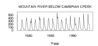
| ID | Year | Jan | Feb | Mar | Apr | May | Jun | Jul | Aug | Sep | Oct | Nov | Dec |
|---|---|---|---|---|---|---|---|---|---|---|---|---|---|
| 3648 | 1978 | 13.00 | 11.00 | 9.00 | 9.00 | 88.40 | 344.00 | 328.00 | 235.00 | 101.00 | 48.20 | 27.00 | 24.00 |
| 3648 | 1979 | 16.00 | 9.00 | 8.00 | 11.00 | 160.00 | 340.00 | 413.00 | 299.00 | 144.00 | 75.50 | 24.00 | 16.00 |
| 3648 | 1980 | 11.00 | 9.00 | 9.00 | 12.00 | 175.00 | 287.00 | 230.00 | 395.00 | 192.00 | 79.00 | 26.00 | 16.00 |
| 3648 | 1981 | 11.00 | 10.00 | 10.00 | 10.00 | 222.00 | 266.00 | 357.00 | 205.00 | 89.70 | 46.80 | 25.00 | 18.00 |
| 3648 | 1982 | 13.00 | 10.00 | 8.00 | 9.00 | 144.00 | 442.00 | 336.00 | 377.00 | 120.00 | 54.90 | 32.00 | 22.00 |
| 3648 | 1983 | 18.00 | 16.00 | 16.00 | 22.00 | 103.00 | 418.00 | 229.00 | 219.00 | 138.00 | 71.40 | 31.00 | 18.00 |
| 3648 | 1984 | 13.00 | 9.00 | 8.00 | 14.00 | 151.00 | 389.00 | 387.00 | 314.00 | 140.00 | 69.20 | 31.00 | 22.00 |
| 3648 | 1985 | 17.00 | 15.00 | 12.00 | 11.00 | 114.00 | 386.00 | 295.00 | 239.00 | 157.00 | 61.20 | 25.00 | 21.00 |
| 3648 | 1986 | 18.00 | 17.00 | 15.00 | 13.00 | 108.00 | 575.00 | 384.00 | 439.00 | 241.00 | 88.10 | 34.00 | 25.00 |
| 3648 | 1987 | 20.00 | 17.00 | 14.00 | 14.00 | 201.00 | 345.00 | 282.00 | 270.00 | 162.00 | 76.20 | 36.00 | 24.00 |
| 3648 | 1988 | 17.00 | 14.00 | 11.00 | 11.00 | 193.00 | 395.00 | 382.00 | 227.00 | 193.00 | 69.40 | 39.00 | 28.00 |
| 3648 | 1989 | 20.00 | 16.00 | 14.00 | 19.00 | 198.00 | 479.00 | 192.00 | 165.00 | 125.00 | 60.70 | 30.00 | 21.00 |
| 3648 | 1990 | 16.00 | 14.00 | 12.00 | 13.00 | 194.00 | 429.00 | 171.00 | 191.00 | 216.00 | 99.70 | 37.00 | 24.00 |
| 3648 | 1991 | 20.00 | 18.00 | 18.00 | 20.00 | 265.00 | 408.00 | 419.00 | 218.00 | 116.00 | 53.80 | 29.00 | 24.00 |
| 3648 | 1992 | 19.00 | 17.00 | 16.00 | 15.00 | 118.00 | 542.00 | 275.00 | 177.00 | 84.10 | 40.20 | 26.00 | 19.00 |
| 3648 | 1993 | 16.00 | 13.00 | 12.00 | 13.00 | 244.00 | 537.00 | 288.00 | 207.00 | 183.00 | 66.60 | 35.00 | 25.00 |
 Return to R-Arctic Net Home Page