| PointID: | 3639 | Code: | 10JD001 | Latitude (decimal degrees): | 66.85 | Longitude (decimal degrees): | -121.26 | Drainage Area (km2): | 3940.00 | Source: | Hydat | Hydrological Zone: | Mackenzie | Name: | HALDANE RIVER NEAR THE MOUTH |
|---|
| Download | |
|---|---|
| Site Descriptor Information | Site Time Series Data |
| Link to all available data | |
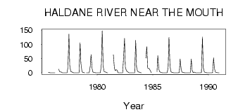
| ID | Year | Jan | Feb | Mar | Apr | May | Jun | Jul | Aug | Sep | Oct | Nov | Dec |
|---|---|---|---|---|---|---|---|---|---|---|---|---|---|
| 3639 | 1975 | 1.78 | 0.85 | 0.31 | 0.00 | 0.00 | |||||||
| 3639 | 1976 | 0.00 | 0.00 | 0.00 | 12.90 | 4.46 | 3.13 | 2.39 | 0.00 | 0.00 | |||
| 3639 | 1977 | 0.00 | 0.00 | 0.00 | 0.00 | 18.50 | 136.00 | 24.20 | 5.04 | 3.90 | 1.97 | 0.00 | 0.00 |
| 3639 | 1978 | 0.00 | 0.00 | 0.00 | 0.00 | 0.00 | 106.00 | 32.70 | 5.61 | 1.16 | 0.53 | 0.00 | |
| 3639 | 1979 | 0.00 | 0.00 | 0.00 | 0.00 | 22.90 | 64.10 | 15.60 | 2.63 | 1.89 | 0.92 | 0.00 | 0.00 |
| 3639 | 1980 | 0.00 | 0.00 | 0.00 | 0.00 | 29.70 | 148.00 | 22.10 | 5.19 | 3.03 | 2.74 | 0.00 | 0.00 |
| 3639 | 1981 | 63.90 | 15.90 | 8.14 | 11.60 | 9.12 | 0.00 | 0.00 | |||||
| 3639 | 1982 | 0.00 | 0.00 | 0.00 | 0.00 | 52.20 | 121.00 | 19.40 | 7.90 | 4.78 | 2.17 | 0.00 | 0.00 |
| 3639 | 1983 | 0.00 | 0.00 | 0.00 | 0.00 | 0.45 | 114.00 | 21.10 | 5.79 | 3.25 | 2.70 | 1.00 | 0.00 |
| 3639 | 1984 | 52.40 | 92.30 | 16.50 | 16.00 | 13.20 | 6.05 | 0.00 | |||||
| 3639 | 1985 | 3.98 | 60.60 | 12.90 | 3.57 | 1.86 | 0.73 | 0.00 | 0.00 | ||||
| 3639 | 1986 | 0.00 | 0.00 | 0.00 | 0.00 | 18.10 | 125.00 | 25.80 | 4.28 | 1.92 | 1.34 | 0.00 | 0.00 |
| 3639 | 1987 | 0.00 | 0.00 | 0.00 | 0.00 | 1.49 | 48.40 | 13.50 | 2.45 | 1.20 | 0.62 | 0.00 | 0.00 |
| 3639 | 1988 | 0.00 | 0.00 | 0.00 | 0.00 | 0.12 | 48.80 | 9.13 | 1.05 | 2.70 | 1.62 | 0.00 | 0.00 |
| 3639 | 1989 | 0.00 | 0.00 | 0.00 | 0.00 | 0.86 | 126.00 | 18.70 | 3.60 | 1.58 | 1.03 | 0.00 | 0.00 |
| 3639 | 1990 | 0.00 | 0.00 | 0.00 | 0.00 | 0.69 | 52.70 | 15.80 | 2.27 | 1.16 | 0.62 | 0.00 | 0.00 |
 Return to R-Arctic Net Home Page