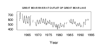
| PointID: | 3638 | Code: | 10JC003 | Latitude (decimal degrees): | 65.13 | Longitude (decimal degrees): | -123.51 | Drainage Area (km2): | 145000.00 | Source: | Hydat | Hydrological Zone: | Mackenzie | Name: | GREAT BEAR RIVER AT OUTLET OF GREAT BEAR LAKE |
|---|
| Download | |
|---|---|
| Site Descriptor Information | Site Time Series Data |
| Link to all available data | |
| ID | Year | Jan | Feb | Mar | Apr | May | Jun | Jul | Aug | Sep | Oct | Nov | Dec |
|---|---|---|---|---|---|---|---|---|---|---|---|---|---|
| 3638 | 1961 | 573.00 | 691.00 | 724.00 | 749.00 | 745.00 | 687.00 | 627.00 | 616.00 | ||||
| 3638 | 1962 | 577.00 | 719.00 | 695.00 | 648.00 | 601.00 | 598.00 | ||||||
| 3638 | 1963 | 579.00 | 561.00 | 551.00 | 530.00 | 537.00 | 608.00 | 654.00 | 672.00 | 679.00 | 606.00 | 578.00 | 564.00 |
| 3638 | 1964 | 547.00 | 530.00 | 520.00 | 514.00 | 520.00 | 638.00 | 680.00 | 672.00 | 655.00 | 635.00 | 645.00 | 589.00 |
| 3638 | 1965 | 551.00 | 533.00 | 548.00 | 525.00 | 515.00 | 566.00 | 637.00 | 654.00 | 655.00 | 669.00 | 642.00 | 647.00 |
| 3638 | 1966 | 597.00 | 600.00 | 548.00 | 464.00 | 514.00 | 595.00 | 670.00 | 683.00 | 677.00 | |||
| 3638 | 1967 | 539.00 | 591.00 | ||||||||||
| 3638 | 1968 | 553.00 | 535.00 | 525.00 | 514.00 | ||||||||
| 3638 | 1969 | 494.00 | 477.00 | 470.00 | 468.00 | 480.00 | 514.00 | 546.00 | 583.00 | 595.00 | 581.00 | 568.00 | 554.00 |
| 3638 | 1970 | 540.00 | 527.00 | 518.00 | 512.00 | 505.00 | 536.00 | 559.00 | 581.00 | 595.00 | 582.00 | 556.00 | 540.00 |
| 3638 | 1971 | 522.00 | 520.00 | 518.00 | 517.00 | 533.00 | 612.00 | 631.00 | 632.00 | 626.00 | 615.00 | 585.00 | 564.00 |
| 3638 | 1972 | 550.00 | 547.00 | 540.00 | 540.00 | 530.00 | 555.00 | 613.00 | 615.00 | 601.00 | 583.00 | 559.00 | 537.00 |
| 3638 | 1973 | 524.00 | 531.00 | 521.00 | 507.00 | 538.00 | 580.00 | 616.00 | 613.00 | 616.00 | 562.00 | 486.00 | 497.00 |
| 3638 | 1974 | 524.00 | 515.00 | 511.00 | 501.00 | 508.00 | 538.00 | 554.00 | 575.00 | 566.00 | 548.00 | 537.00 | 534.00 |
| 3638 | 1975 | 538.00 | 541.00 | 524.00 | 509.00 | 528.00 | 583.00 | 591.00 | 583.00 | 571.00 | 552.00 | 522.00 | 510.00 |
| 3638 | 1976 | 508.00 | 503.00 | 494.00 | 494.00 | 513.00 | 534.00 | 541.00 | 549.00 | 539.00 | 518.00 | 484.00 | 459.00 |
| 3638 | 1977 | 449.00 | 442.00 | 445.00 | 460.00 | 511.00 | 523.00 | 549.00 | 540.00 | 529.00 | 514.00 | 487.00 | 487.00 |
| 3638 | 1978 | 477.00 | 470.00 | 453.00 | 440.00 | 448.00 | 481.00 | 501.00 | 506.00 | 505.00 | 484.00 | 454.00 | 436.00 |
| 3638 | 1979 | 481.00 | 427.00 | 400.00 | 399.00 | 431.00 | 491.00 | 499.00 | 494.00 | 496.00 | 484.00 | 456.00 | 424.00 |
| 3638 | 1980 | 424.00 | 427.00 | 425.00 | 423.00 | 460.00 | 504.00 | 519.00 | 530.00 | 525.00 | 521.00 | 485.00 | 457.00 |
| 3638 | 1981 | 459.00 | 452.00 | 457.00 | 453.00 | 459.00 | 484.00 | 490.00 | 498.00 | 481.00 | 486.00 | ||
| 3638 | 1982 | 468.00 | 459.00 | 443.00 | 442.00 | 446.00 | 486.00 | 521.00 | 534.00 | 532.00 | 519.00 | ||
| 3638 | 1983 | 507.00 | 531.00 | 540.00 | 542.00 | ||||||||
| 3638 | 1984 | 532.00 | 592.00 | 570.00 | 559.00 | ||||||||
| 3638 | 1985 | 558.00 | 549.00 | 539.00 | 531.00 | 542.00 | 583.00 | 592.00 | 612.00 | 599.00 | 578.00 | 525.00 | 540.00 |
| 3638 | 1986 | 536.00 | 524.00 | 517.00 | 506.00 | 514.00 | 578.00 | 594.00 | 607.00 | 599.00 | 574.00 | 553.00 | 545.00 |
| 3638 | 1987 | 530.00 | 517.00 | 520.00 | 526.00 | 523.00 | 555.00 | 555.00 | 555.00 | 547.00 | 530.00 | 501.00 | 498.00 |
| 3638 | 1988 | 485.00 | 483.00 | 474.00 | 476.00 | 459.00 | 482.00 | 495.00 | 496.00 | 517.00 | 524.00 | 509.00 | 503.00 |
| 3638 | 1989 | 490.00 | 479.00 | 471.00 | 468.00 | 476.00 | 518.00 | 533.00 | 534.00 | 519.00 | 513.00 | 489.00 | 490.00 |
| 3638 | 1990 | 477.00 | 463.00 | 446.00 | 456.00 | 448.00 | 477.00 | 491.00 | |||||
| 3638 | 1991 | 441.00 | 444.00 | 471.00 | 521.00 | 537.00 | 548.00 | 551.00 | 540.00 | 514.00 | |||
| 3638 | 1992 | 501.00 | 494.00 | 492.00 | 495.00 | 570.00 | 594.00 | 607.00 | 592.00 | 577.00 | |||
| 3638 | 1993 | 506.00 | 584.00 | 609.00 | 613.00 | 601.00 | 583.00 |
 Return to R-Arctic Net Home Page