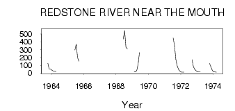
| PointID: | 3628 | Code: | 10HB001 | Latitude (decimal degrees): | 64.18 | Longitude (decimal degrees): | -124.66 | Drainage Area (km2): | 16400.00 | Source: | Hydat | Hydrological Zone: | Mackenzie | Name: | REDSTONE RIVER NEAR THE MOUTH |
|---|
| Download | |
|---|---|
| Site Descriptor Information | Site Time Series Data |
| Link to all available data | |
| ID | Year | Jan | Feb | Mar | Apr | May | Jun | Jul | Aug | Sep | Oct | Nov | Dec |
|---|---|---|---|---|---|---|---|---|---|---|---|---|---|
| 3628 | 1963 | 124.00 | 49.00 | 51.00 | |||||||||
| 3628 | 1964 | 38.00 | 27.00 | 25.00 | 21.00 | 94.60 | |||||||
| 3628 | 1965 | 295.00 | 369.00 | 197.00 | 153.00 | ||||||||
| 3628 | 1966 | 201.00 | |||||||||||
| 3628 | 1967 | 197.00 | |||||||||||
| 3628 | 1968 | 435.00 | 545.00 | 330.00 | 308.00 | ||||||||
| 3628 | 1969 | 15.00 | 14.00 | 36.00 | 117.00 | 263.00 | |||||||
| 3628 | 1970 | 274.00 | 263.00 | ||||||||||
| 3628 | 1971 | 449.00 | 351.00 | 173.00 | 93.50 | 47.00 | 24.00 | ||||||
| 3628 | 1972 | 12.00 | 11.00 | 12.00 | 171.00 | 84.60 | 48.00 | 31.00 | |||||
| 3628 | 1973 | 16.00 | 13.00 | 14.00 | 122.00 | 79.00 | 38.00 | ||||||
| 3628 | 1974 | 17.00 | 13.00 | 12.00 |
 Return to R-Arctic Net Home Page