| PointID: | 3621 | Code: | 10GB006 | Latitude (decimal degrees): | 62.65 | Longitude (decimal degrees): | -122.89 | Drainage Area (km2): | 20200.00 | Source: | Hydat | Hydrological Zone: | Mackenzie | Name: | WILLOWLAKE RIVER ABOVE METAHDALI CREEK |
|---|
| Download | |
|---|---|
| Site Descriptor Information | Site Time Series Data |
| Link to all available data | |
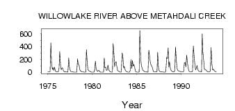
| ID | Year | Jan | Feb | Mar | Apr | May | Jun | Jul | Aug | Sep | Oct | Nov | Dec |
|---|---|---|---|---|---|---|---|---|---|---|---|---|---|
| 3621 | 1975 | 7.00 | 6.00 | 4.00 | 5.00 | 460.00 | 149.00 | 43.00 | 75.80 | 29.50 | 79.20 | 19.00 | 9.00 |
| 3621 | 1976 | 7.00 | 5.00 | 4.00 | 65.00 | 323.00 | 120.00 | 39.70 | 68.60 | 65.60 | 24.60 | 8.00 | 4.00 |
| 3621 | 1977 | 6.00 | 4.00 | 3.00 | 5.00 | 224.00 | 81.90 | 38.80 | 9.62 | 8.73 | 9.09 | 5.00 | 3.00 |
| 3621 | 1978 | 2.00 | 2.00 | 1.00 | 1.00 | 209.00 | 124.00 | 114.00 | 46.40 | 18.70 | 16.10 | 8.00 | 5.00 |
| 3621 | 1979 | 4.00 | 2.00 | 2.00 | 2.00 | 354.00 | 151.00 | 43.40 | 24.90 | 16.80 | 13.20 | 5.00 | 3.00 |
| 3621 | 1980 | 2.00 | 2.00 | 2.00 | 34.00 | 177.00 | 59.40 | 26.00 | 11.00 | 26.00 | 27.10 | 6.00 | 3.00 |
| 3621 | 1981 | 2.00 | 2.00 | 1.00 | 2.00 | 224.00 | 69.60 | 77.10 | 28.50 | 37.00 | 114.00 | 37.00 | 21.00 |
| 3621 | 1982 | 8.00 | 4.00 | 3.00 | 3.00 | 449.00 | 296.00 | 87.70 | 154.00 | 167.00 | 81.00 | 25.00 | 20.00 |
| 3621 | 1983 | 12.00 | 5.00 | 3.00 | 4.00 | 302.00 | 268.00 | 65.80 | 92.40 | 40.90 | 22.10 | 12.00 | 8.00 |
| 3621 | 1984 | 3.00 | 2.00 | 3.00 | 31.00 | 197.00 | 60.30 | 187.00 | 96.50 | 121.00 | 79.50 | 13.00 | 7.00 |
| 3621 | 1985 | 3.00 | 2.00 | 2.00 | 4.00 | 654.00 | 234.00 | 111.00 | 63.40 | 33.20 | 22.80 | 11.00 | 8.00 |
| 3621 | 1986 | 6.00 | 4.00 | 3.00 | 3.00 | 346.00 | 264.00 | 154.00 | 116.00 | 94.10 | 69.70 | 13.00 | 10.00 |
| 3621 | 1987 | 9.00 | 7.00 | 5.00 | 13.00 | 315.00 | 68.30 | 24.00 | 8.61 | 7.64 | 9.61 | 5.00 | 4.00 |
| 3621 | 1988 | 3.00 | 2.00 | 2.00 | 16.00 | 233.00 | 213.00 | 381.00 | 81.10 | 166.00 | 60.50 | 33.00 | 18.00 |
| 3621 | 1989 | 10.00 | 7.00 | 4.00 | 28.00 | 396.00 | 217.00 | 65.00 | 30.90 | 19.60 | 17.40 | 12.00 | 10.00 |
| 3621 | 1990 | 8.00 | 6.00 | 5.00 | 11.00 | 151.00 | 153.00 | 82.90 | 270.00 | 155.00 | 64.90 | 20.00 | 11.00 |
| 3621 | 1991 | 7.00 | 6.00 | 5.00 | 23.00 | 411.00 | 271.00 | 119.00 | 38.00 | 56.00 | 106.00 | 47.00 | 19.00 |
| 3621 | 1992 | 13.00 | 11.00 | 10.00 | 8.00 | 601.00 | 316.00 | 182.00 | 51.60 | 37.40 | 37.50 | 19.00 | 12.00 |
| 3621 | 1993 | 7.00 | 5.00 | 5.00 | 26.00 | 388.00 | 136.00 | 38.90 | 50.70 | 26.70 | 17.90 | 7.00 | 7.00 |
| Other Close Sites | ||||||
|---|---|---|---|---|---|---|
| PointID | Latitude | Longitude | Drainage Area | Source | Name | |
| 3619 | 62.65 | -122.90 | 20500.00 | Hydat | WILLOWLAKE RIVER BELOW METAHDALI CREEK | |
 Return to R-Arctic Net Home Page