| PointID: | 3620 | Code: | 10GB005 | Latitude (decimal degrees): | 62.64 | Longitude (decimal degrees): | -122.90 | Drainage Area (km2): | 344.00 | Source: | Hydat | Hydrological Zone: | Mackenzie | Name: | METAHDALI CREEK ABOVE WILLOWLAKE RIVER |
|---|
| Download | |
|---|---|
| Site Descriptor Information | Site Time Series Data |
| Link to all available data | |
| ID | Year | Jan | Feb | Mar | Apr | May | Jun | Jul | Aug | Sep | Oct | Nov | Dec |
|---|---|---|---|---|---|---|---|---|---|---|---|---|---|
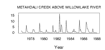
| 3620 | 1976 | 1.54 | 0.88 | 0.07 | 0.00 | 0.00 | |||||||
| 3620 | 1977 | 0.00 | 0.00 | 0.00 | 0.00 | 6.47 | 1.63 | 1.01 | 0.01 | 0.01 | 7.0e-03 | 0.00 | 0.00 |
| 3620 | 1978 | 0.00 | 0.00 | 0.00 | 0.00 | 2.71 | 2.13 | 2.48 | 0.43 | 0.04 | 0.02 | 0.00 | 0.00 |
| 3620 | 1979 | 0.00 | 0.00 | 0.00 | 0.00 | 8.40 | 1.23 | 0.12 | 0.95 | 0.73 | 0.41 | 0.00 | 0.00 |
| 3620 | 1980 | 0.00 | 0.00 | 0.00 | 0.00 | 2.45 | 0.53 | 0.20 | 0.03 | 0.26 | 0.21 | 0.00 | 0.00 |
| 3620 | 1981 | 0.00 | 0.00 | 0.00 | 0.00 | 6.42 | 0.28 | 0.69 | 0.14 | 0.30 | 2.13 | 0.00 | 0.00 |
| 3620 | 1982 | 0.00 | 0.00 | 0.00 | 0.00 | 16.50 | 4.08 | 0.20 | 6.89 | 5.29 | 0.53 | 0.00 | 0.00 |
| 3620 | 1983 | 0.00 | 0.00 | 0.00 | 0.00 | 10.80 | 2.46 | 0.14 | 0.61 | 0.15 | 0.02 | 0.00 | 0.00 |
| 3620 | 1984 | 0.00 | 0.00 | 0.00 | 0.00 | 1.52 | 0.63 | 3.12 | 0.36 | 0.73 | 0.96 | 0.00 | 0.00 |
| 3620 | 1985 | 0.00 | 0.00 | 0.00 | 0.00 | 11.10 | 1.78 | 2.69 | 0.53 | 0.24 | 0.08 | 0.00 | 0.00 |
| 3620 | 1986 | 0.00 | 0.00 | 0.00 | 0.00 | 9.32 | 7.55 | 3.12 | 3.39 | 1.66 | 0.58 | 0.00 | 0.00 |
| 3620 | 1987 | 0.00 | 0.00 | 0.00 | 0.00 | 3.41 | 0.32 | 0.08 | 0.01 | 0.01 | 0.02 | 0.00 | 0.00 |
 Return to R-Arctic Net Home Page