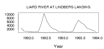
| PointID: | 3611 | Code: | 10ED008 | Latitude (decimal degrees): | 61.11 | Longitude (decimal degrees): | -122.85 | Drainage Area (km2): | Source: | Hydat | Hydrological Zone: | Mackenzie | Name: | LIARD RIVER AT LINDBERG LANDING |
|---|
| Download | |
|---|---|
| Site Descriptor Information | Site Time Series Data |
| Link to all available data | |
| ID | Year | Jan | Feb | Mar | Apr | May | Jun | Jul | Aug | Sep | Oct | Nov | Dec |
|---|---|---|---|---|---|---|---|---|---|---|---|---|---|
| 3611 | 1991 | 2510.00 | 768.00 | 752.00 | |||||||||
| 3611 | 1992 | 654.00 | 529.00 | 522.00 | 661.00 | 4800.00 | 10500.00 | 6210.00 | 3610.00 | 2220.00 | 1770.00 | 661.00 | 639.00 |
| 3611 | 1993 | 523.00 | 449.00 | 432.00 | 736.00 | 4220.00 | 6770.00 | 5340.00 | 4400.00 | 2420.00 | 1930.00 | 1110.00 | 710.00 |
 Return to R-Arctic Net Home Page