| PointID: | 3605 | Code: | 10ED002 | Latitude (decimal degrees): | 61.74 | Longitude (decimal degrees): | -121.22 | Drainage Area (km2): | 275000.00 | Source: | Hydat | Hydrological Zone: | Mackenzie | Name: | LIARD RIVER NEAR THE MOUTH |
|---|
| Download | |
|---|---|
| Site Descriptor Information | Site Time Series Data |
| Link to all available data | |
| ID | Year | Jan | Feb | Mar | Apr | May | Jun | Jul | Aug | Sep | Oct | Nov | Dec |
|---|---|---|---|---|---|---|---|---|---|---|---|---|---|
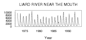
| 3605 | 1972 | 9440.00 | 5680.00 | 4140.00 | 2140.00 | 1820.00 | 688.00 | 640.00 | |||||
| 3605 | 1973 | 460.00 | 394.00 | 387.00 | 606.00 | 4840.00 | 9350.00 | 5490.00 | 2900.00 | 2930.00 | 1520.00 | 651.00 | 492.00 |
| 3605 | 1974 | 375.00 | 322.00 | 321.00 | 448.00 | 5520.00 | 6880.00 | 7230.00 | 5570.00 | 2770.00 | 2270.00 | 791.00 | 556.00 |
| 3605 | 1975 | 564.00 | 486.00 | 411.00 | 596.00 | 3230.00 | 7030.00 | 7340.00 | 4490.00 | 2380.00 | 1610.00 | 634.00 | 598.00 |
| 3605 | 1976 | 504.00 | 444.00 | 418.00 | 687.00 | 4660.00 | 7720.00 | 9130.00 | 5910.00 | 3700.00 | 1880.00 | 1010.00 | 607.00 |
| 3605 | 1977 | 600.00 | 601.00 | 598.00 | 748.00 | 4510.00 | 11000.00 | 6640.00 | 4280.00 | 2530.00 | 1790.00 | 593.00 | 371.00 |
| 3605 | 1978 | 417.00 | 376.00 | 397.00 | 382.00 | 2880.00 | 5030.00 | 3520.00 | 2920.00 | 2620.00 | 1710.00 | 517.00 | 359.00 |
| 3605 | 1979 | 337.00 | 351.00 | 379.00 | 423.00 | 3380.00 | 8480.00 | 7990.00 | 3620.00 | 2840.00 | 1750.00 | 490.00 | 360.00 |
| 3605 | 1980 | 395.00 | 385.00 | 316.00 | 446.00 | 2550.00 | 5180.00 | 5070.00 | 3260.00 | 2710.00 | 2920.00 | 1020.00 | 590.00 |
| 3605 | 1981 | 559.00 | 444.00 | 424.00 | 415.00 | 5830.00 | 7040.00 | 3710.00 | 2050.00 | 2390.00 | 1590.00 | 904.00 | 671.00 |
| 3605 | 1982 | 541.00 | 422.00 | 401.00 | 394.00 | 5220.00 | 6720.00 | 3350.00 | 2350.00 | 1760.00 | 1080.00 | 496.00 | 597.00 |
| 3605 | 1983 | 464.00 | 353.00 | 281.00 | 498.00 | 3790.00 | 5980.00 | 3300.00 | 2760.00 | 1780.00 | 1060.00 | 541.00 | 405.00 |
| 3605 | 1984 | 300.00 | 317.00 | 340.00 | 599.00 | 2880.00 | 7160.00 | 5850.00 | 3710.00 | 3300.00 | 1700.00 | 619.00 | 554.00 |
| 3605 | 1985 | 459.00 | 366.00 | 338.00 | 401.00 | 4560.00 | 6570.00 | 6170.00 | 3520.00 | 3900.00 | 2350.00 | 509.00 | 555.00 |
| 3605 | 1986 | 499.00 | 428.00 | 314.00 | 381.00 | 3990.00 | 6990.00 | 7870.00 | 3630.00 | 2260.00 | 3230.00 | 878.00 | 879.00 |
| 3605 | 1987 | 628.00 | 455.00 | 402.00 | 628.00 | 3520.00 | 7740.00 | 6340.00 | 5450.00 | 3360.00 | 2500.00 | 1200.00 | 859.00 |
| 3605 | 1988 | 722.00 | 634.00 | 549.00 | 765.00 | 6980.00 | 9470.00 | 10300.00 | 4740.00 | 2930.00 | 2160.00 | 1100.00 | 979.00 |
| 3605 | 1989 | 689.00 | 584.00 | 529.00 | 608.00 | 6760.00 | 6220.00 | 3720.00 | 2890.00 | 1790.00 | 1480.00 | 672.00 | 870.00 |
| 3605 | 1990 | 614.00 | 488.00 | 447.00 | 841.00 | 4870.00 | 9010.00 | 5070.00 | 3130.00 | 2370.00 | 1610.00 | 514.00 | 611.00 |
| 3605 | 1991 | 502.00 | 473.00 | 416.00 | 901.00 | 5030.00 | 6140.00 | 6400.00 | 3590.00 | 3630.00 | 2600.00 | 874.00 | 887.00 |
| 3605 | 1992 | 759.00 | 578.00 | 549.00 | 659.00 | 5100.00 | 10500.00 | 6010.00 | 3580.00 | 2210.00 | 1820.00 | 745.00 | 693.00 |
| 3605 | 1993 | 563.00 | 514.00 | 478.00 | 741.00 | 4160.00 | 6600.00 | 5150.00 | 4250.00 | 2450.00 | 1960.00 | 1170.00 | 754.00 |
| Other Close Sites | ||||||
|---|---|---|---|---|---|---|
| PointID | Latitude | Longitude | Drainage Area | Source | Name | |
| 3622 | 61.86 | -121.35 | 1270000.00 | Hydat | MACKENZIE RIVER AT FORT SIMPSON | |
 Return to R-Arctic Net Home Page