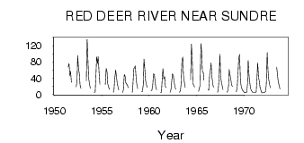
| PointID: | 360 | Code: | 05CA001 | Latitude (decimal degrees): | 51.70 | Longitude (decimal degrees): | -114.85 | Drainage Area (km2): | 2490.00 | Source: | Hydat | Hydrological Zone: | Nelson | Name: | RED DEER RIVER NEAR SUNDRE |
|---|
| Download | |
|---|---|
| Site Descriptor Information | Site Time Series Data |
| Link to all available data | |
| ID | Year | Jan | Feb | Mar | Apr | May | Jun | Jul | Aug | Sep | Oct | Nov | Dec |
|---|---|---|---|---|---|---|---|---|---|---|---|---|---|
| 360 | 1950 | 11.30 | |||||||||||
| 360 | 1951 | 67.30 | 75.70 | 45.50 | 56.70 | 29.90 | |||||||
| 360 | 1952 | 18.00 | 32.20 | 95.70 | 63.80 | 49.90 | 23.40 | 14.70 | |||||
| 360 | 1953 | 33.10 | 136.00 | 79.80 | 39.20 | 24.60 | 14.20 | ||||||
| 360 | 1954 | 4.00 | 6.00 | 38.10 | 93.00 | 76.00 | 92.90 | 54.40 | 24.60 | ||||
| 360 | 1955 | 24.50 | 63.40 | 56.40 | 26.30 | 18.40 | 12.00 | ||||||
| 360 | 1956 | 5.00 | 9.00 | 39.60 | 59.90 | 46.20 | 28.30 | 17.60 | 10.40 | ||||
| 360 | 1957 | 4.00 | 12.00 | 49.00 | 44.60 | 28.30 | 25.00 | 21.50 | 16.00 | ||||
| 360 | 1958 | 5.00 | 24.00 | 62.90 | 66.50 | 70.20 | 38.30 | 24.60 | 13.80 | ||||
| 360 | 1959 | 6.00 | 7.00 | 24.30 | 87.10 | 62.00 | 32.60 | 24.40 | 16.80 | ||||
| 360 | 1960 | 9.00 | 10.00 | 24.30 | 50.40 | 48.60 | 30.90 | 16.10 | 11.30 | ||||
| 360 | 1961 | 4.00 | 5.00 | 41.50 | 63.20 | 37.70 | 43.10 | 19.60 | 16.60 | ||||
| 360 | 1962 | 5.00 | 11.00 | 28.20 | 50.50 | 46.60 | 34.20 | 20.30 | 12.20 | ||||
| 360 | 1963 | 5.00 | 9.00 | 25.70 | 84.00 | 91.70 | 47.00 | 30.50 | 17.00 | ||||
| 360 | 1964 | 35.50 | 124.00 | 81.80 | 27.60 | 20.90 | 17.80 | ||||||
| 360 | 1965 | 7.00 | 14.00 | 21.90 | 125.00 | 107.00 | 55.30 | 53.50 | 34.50 | ||||
| 360 | 1966 | 11.00 | 10.00 | 45.90 | 60.30 | 77.20 | 43.00 | 25.30 | 16.70 | ||||
| 360 | 1967 | 5.00 | 9.00 | 40.30 | 99.10 | 45.90 | 29.20 | 19.70 | 11.70 | ||||
| 360 | 1968 | 5.00 | 8.00 | 20.60 | 61.00 | 47.00 | 35.30 | 22.80 | 19.00 | ||||
| 360 | 1969 | 6.00 | 18.00 | 55.40 | 89.00 | 98.40 | 36.70 | 21.40 | 13.00 | 9.00 | 7.00 | ||
| 360 | 1970 | 4.00 | 5.00 | 4.00 | 5.00 | 25.80 | 84.00 | 45.30 | 26.50 | 14.00 | 8.96 | 6.00 | 4.00 |
| 360 | 1971 | 4.00 | 4.00 | 4.00 | 6.00 | 33.20 | 78.00 | 41.40 | 33.40 | 16.60 | 9.37 | 5.00 | 3.00 |
| 360 | 1972 | 4.00 | 4.00 | 5.00 | 7.00 | 25.80 | 103.00 | 57.50 | 37.10 | 24.30 | 15.70 | ||
| 360 | 1973 | 67.20 | 45.90 | 31.30 | 22.40 | 13.30 |
 Return to R-Arctic Net Home Page