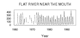
| PointID: | 3597 | Code: | 10EA003 | Latitude (decimal degrees): | 61.53 | Longitude (decimal degrees): | -125.41 | Drainage Area (km2): | 8560.00 | Source: | Hydat | Hydrological Zone: | Mackenzie | Name: | FLAT RIVER NEAR THE MOUTH |
|---|
| Download | |
|---|---|
| Site Descriptor Information | Site Time Series Data |
| Link to all available data | |
| ID | Year | Jan | Feb | Mar | Apr | May | Jun | Jul | Aug | Sep | Oct | Nov | Dec |
|---|---|---|---|---|---|---|---|---|---|---|---|---|---|
| 3597 | 1960 | 23.00 | 19.00 | 18.00 | |||||||||
| 3597 | 1961 | 17.00 | 15.00 | 14.00 | 364.00 | 153.00 | 95.90 | 77.80 | 43.10 | 22.00 | 22.00 | ||
| 3597 | 1962 | 20.00 | 17.00 | 14.00 | 290.00 | 171.00 | 111.00 | 82.30 | 37.00 | 29.00 | |||
| 3597 | 1963 | 26.00 | 22.00 | 19.00 | 29.00 | 218.00 | 358.00 | 296.00 | 133.00 | 145.00 | 82.40 | 34.00 | 22.00 |
| 3597 | 1964 | 20.00 | 19.00 | 19.00 | 19.00 | 384.00 | 213.00 | 175.00 | 113.00 | 58.60 | 33.00 | 28.00 | |
| 3597 | 1965 | 20.00 | 17.00 | 15.00 | 17.00 | 114.00 | 174.00 | 190.00 | 96.60 | 69.80 | |||
| 3597 | 1966 | 229.00 | 184.00 | 124.00 | 78.50 | ||||||||
| 3597 | 1967 | 89.20 | 62.30 | ||||||||||
| 3597 | 1968 | 272.00 | 294.00 | 237.00 | 178.00 | ||||||||
| 3597 | 1969 | 221.00 | 134.00 | 145.00 | 98.30 | 56.30 | |||||||
| 3597 | 1970 | 118.00 | 92.10 | 65.30 | 29.00 | 17.00 | |||||||
| 3597 | 1971 | 307.00 | 149.00 | 87.70 | 69.40 | ||||||||
| 3597 | 1972 | 328.00 | 393.00 | 185.00 | 77.10 | 42.20 | 19.00 | 15.00 | |||||
| 3597 | 1973 | 13.00 | 10.00 | 8.00 | 15.00 | 253.00 | 393.00 | 158.00 | 101.00 | 128.00 | 35.90 | 19.00 | 16.00 |
| 3597 | 1974 | 13.00 | 12.00 | 12.00 | 16.00 | 176.00 | 310.00 | 215.00 | 240.00 | 112.00 | 52.70 | 24.00 | 24.00 |
| 3597 | 1975 | 20.00 | 18.00 | 15.00 | 19.00 | 212.00 | 321.00 | 241.00 | 150.00 | 90.50 | 67.30 | 32.00 | 28.00 |
| 3597 | 1976 | 22.00 | 17.00 | 14.00 | 30.00 | 278.00 | 257.00 | 250.00 | 174.00 | 105.00 | 57.30 | 27.00 | 20.00 |
| 3597 | 1977 | 16.00 | 14.00 | 13.00 | 20.00 | 164.00 | 242.00 | 220.00 | 208.00 | 140.00 | 74.10 | 20.00 | 14.00 |
| 3597 | 1978 | 13.00 | 14.00 | 14.00 | 14.00 | 79.00 | 167.00 | 281.00 | 151.00 | 81.90 | 64.30 | 29.00 | 23.00 |
| 3597 | 1979 | 18.00 | 14.00 | 14.00 | 15.00 | 192.00 | 287.00 | 248.00 | 149.00 | 135.00 | 50.40 | 22.00 | 19.00 |
| 3597 | 1980 | 20.00 | 20.00 | 20.00 | 27.00 | 131.00 | 224.00 | 162.00 | 110.00 | 133.00 | 101.00 | 43.00 | 29.00 |
| 3597 | 1981 | 23.00 | 16.00 | 15.00 | 16.00 | 196.00 | 258.00 | 131.00 | 81.40 | 81.30 | 41.60 | 24.00 | 22.00 |
| 3597 | 1982 | 17.00 | 14.00 | 12.00 | 12.00 | 176.00 | 298.00 | 121.00 | 130.00 | 63.70 | 34.50 | 23.00 | 22.00 |
| 3597 | 1983 | 18.00 | 13.00 | 12.00 | 13.00 | 140.00 | 182.00 | 140.00 | 150.00 | 77.80 | 41.10 | 20.00 | 17.00 |
| 3597 | 1984 | 12.00 | 11.00 | 11.00 | 20.00 | 137.00 | 283.00 | 170.00 | 120.00 | 84.80 | 40.10 | 20.00 | 19.00 |
| 3597 | 1985 | 14.00 | 11.00 | 11.00 | 15.00 | 187.00 | 219.00 | 193.00 | 102.00 | 70.50 | 43.20 | 16.00 | 14.00 |
| 3597 | 1986 | 11.00 | 6.00 | 4.00 | 11.00 | 172.00 | 264.00 | 327.00 | 170.00 | 89.50 | 73.20 | 29.00 | 27.00 |
| 3597 | 1987 | 21.00 | 15.00 | 13.00 | 16.00 | 224.00 | 243.00 | 197.00 | 152.00 | 102.00 | 54.10 | 28.00 | 26.00 |
| 3597 | 1988 | 21.00 | 17.00 | 15.00 | 21.00 | 199.00 | 426.00 | 350.00 | 172.00 | 124.00 | 74.40 | 55.00 | 40.00 |
| 3597 | 1989 | 28.00 | 19.00 | 16.00 | 47.00 | 225.00 | 247.00 | 162.00 | 112.00 | 69.50 | 43.80 | 31.00 | 24.00 |
| 3597 | 1990 | 17.00 | 15.00 | 15.00 | 20.00 | 212.00 | 265.00 | 168.00 | 165.00 | 100.00 | 55.50 | 30.00 | 24.00 |
| 3597 | 1991 | 21.00 | 22.00 | 15.00 | 57.00 | 236.00 | 234.00 | 263.00 | 146.00 | 139.00 | 70.40 | 41.00 | 32.00 |
| 3597 | 1992 | 22.00 | 21.00 | 18.00 | 33.00 | 205.00 | 451.00 | 312.00 | 197.00 | 117.00 | 56.30 | 33.00 | 30.00 |
| 3597 | 1993 | 21.00 | 21.00 | 20.00 | 31.00 | 217.00 | 261.00 | 209.00 | 125.00 | 80.20 | 59.10 | 27.00 | 23.00 |
 Return to R-Arctic Net Home Page