| PointID: | 3596 | Code: | 10EA002 | Latitude (decimal degrees): | 61.97 | Longitude (decimal degrees): | -128.23 | Drainage Area (km2): | 155.00 | Source: | Hydat | Hydrological Zone: | Mackenzie | Name: | FLAT RIVER AT CANTUNG CAMP |
|---|
| Download | |
|---|---|
| Site Descriptor Information | Site Time Series Data |
| Link to all available data | |
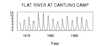
| ID | Year | Jan | Feb | Mar | Apr | May | Jun | Jul | Aug | Sep | Oct | Nov | Dec |
|---|---|---|---|---|---|---|---|---|---|---|---|---|---|
| 3596 | 1973 | 5.12 | 3.08 | 1.32 | 0.00 | 0.00 | |||||||
| 3596 | 1974 | 0.00 | 0.00 | 0.00 | 0.00 | 1.55 | 6.29 | 6.83 | 7.01 | 2.97 | 1.22 | 0.00 | 0.00 |
| 3596 | 1975 | 0.00 | 0.00 | 0.00 | 0.00 | 1.49 | 8.83 | 8.71 | 3.45 | 3.48 | 1.66 | 0.00 | 0.00 |
| 3596 | 1976 | 0.00 | 0.00 | 0.00 | 0.00 | 5.76 | 5.17 | 6.24 | 5.01 | 2.30 | 1.22 | 0.00 | 0.00 |
| 3596 | 1977 | 0.00 | 0.00 | 0.00 | 0.00 | 2.20 | 11.90 | 7.48 | 7.60 | 2.64 | 1.38 | 0.00 | 0.00 |
| 3596 | 1978 | 0.00 | 0.00 | 0.00 | 0.00 | 1.32 | 8.68 | 11.60 | 3.62 | 1.82 | 1.16 | 0.00 | 0.00 |
| 3596 | 1979 | 0.00 | 0.00 | 0.00 | 0.00 | 0.94 | 9.57 | 9.88 | 6.92 | 2.83 | 1.56 | 0.00 | 0.00 |
| 3596 | 1980 | 0.00 | 0.00 | 0.00 | 0.00 | 2.00 | 7.87 | 7.40 | 5.88 | 2.61 | 1.93 | 1.00 | 0.00 |
| 3596 | 1981 | 0.00 | 0.00 | 0.00 | 0.00 | 4.26 | 5.75 | 5.96 | 4.38 | 2.69 | 1.26 | 0.00 | 0.00 |
| 3596 | 1982 | 0.00 | 0.00 | 0.00 | 0.00 | 1.31 | 7.68 | 5.76 | 4.42 | 2.55 | 1.53 | 0.00 | 0.00 |
| 3596 | 1983 | 0.00 | 0.00 | 0.00 | 0.00 | 1.50 | 9.55 | 8.01 | 6.88 | 2.96 | 1.23 | 0.00 | 0.00 |
| 3596 | 1984 | 0.00 | 0.00 | 0.00 | 0.00 | 1.38 | 5.46 | 6.77 | 6.01 | 2.27 | 1.12 | 0.00 | 0.00 |
| 3596 | 1985 | 0.00 | 0.00 | 0.00 | 0.00 | 0.95 | 6.04 | 9.16 | 5.13 | 2.88 | 1.39 | 0.00 | 0.00 |
| 3596 | 1986 | 0.00 | 0.00 | 0.00 | 0.00 | 1.15 | 6.60 | 9.09 | 5.35 | 2.43 | 1.08 | 0.00 | 0.00 |
| 3596 | 1987 | 0.00 | 0.00 | 0.00 | 0.00 | 1.26 | 7.05 | 6.95 | 5.08 | 3.70 | 1.68 | 0.00 | 0.00 |
| 3596 | 1988 | 0.00 | 0.00 | 0.00 | 0.00 |
 Return to R-Arctic Net Home Page