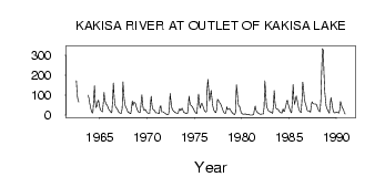
| PointID: | 3595 | Code: | 07UC001 | Latitude (decimal degrees): | 60.94 | Longitude (decimal degrees): | -117.42 | Drainage Area (km2): | 15600.00 | Source: | Hydat | Hydrological Zone: | Mackenzie | Name: | KAKISA RIVER AT OUTLET OF KAKISA LAKE |
|---|
| Download | |
|---|---|
| Site Descriptor Information | Site Time Series Data |
| Link to all available data | |
| ID | Year | Jan | Feb | Mar | Apr | May | Jun | Jul | Aug | Sep | Oct | Nov | Dec |
|---|---|---|---|---|---|---|---|---|---|---|---|---|---|
| 3595 | 1962 | 172.00 | 101.00 | 76.40 | 65.40 | ||||||||
| 3595 | 1963 | 100.00 | 85.00 | 60.00 | |||||||||
| 3595 | 1964 | 39.00 | 23.00 | 12.00 | 11.00 | 73.90 | 147.00 | 65.80 | 37.90 | 46.10 | 70.10 | 75.00 | 50.00 |
| 3595 | 1965 | 32.00 | 23.00 | 19.00 | 17.00 | 56.90 | 113.00 | 72.00 | 62.50 | 51.70 | 50.20 | 41.00 | 31.00 |
| 3595 | 1966 | 24.00 | 19.00 | 14.00 | 13.00 | 70.40 | 161.00 | 91.10 | 51.50 | 38.90 | 34.80 | 30.00 | 21.00 |
| 3595 | 1967 | 14.00 | 11.00 | 9.00 | 9.00 | 35.40 | 167.00 | 105.00 | 65.30 | 44.80 | 36.50 | 28.00 | 21.00 |
| 3595 | 1968 | 14.00 | 12.00 | 8.00 | 7.00 | 32.10 | 70.70 | 48.00 | 63.80 | 63.40 | 58.00 | 42.00 | 30.00 |
| 3595 | 1969 | 21.00 | 15.00 | 13.00 | 13.00 | 63.30 | 102.00 | 51.90 | 28.50 | 24.80 | 29.20 | 24.00 | 16.00 |
| 3595 | 1970 | 12.00 | 10.00 | 8.00 | 8.00 | 54.60 | 95.00 | 50.20 | 31.40 | 25.60 | 23.80 | 16.00 | 11.00 |
| 3595 | 1971 | 11.00 | 11.00 | 9.00 | 7.00 | 40.20 | 47.30 | 16.90 | 15.70 | 16.50 | 13.60 | 9.00 | 8.00 |
| 3595 | 1972 | 5.00 | 3.00 | 2.00 | 5.00 | 28.10 | 108.00 | 70.30 | 39.30 | 27.00 | 22.10 | 18.00 | 14.00 |
| 3595 | 1973 | 12.00 | 10.00 | 9.00 | 8.00 | 24.60 | 31.90 | 23.60 | 27.10 | 35.50 | 25.20 | 14.00 | 13.00 |
| 3595 | 1974 | 11.00 | 8.00 | 7.00 | 8.00 | 34.50 | 95.30 | 65.90 | 50.80 | 46.40 | 42.80 | 35.00 | 28.00 |
| 3595 | 1975 | 18.00 | 14.00 | 9.00 | 10.00 | 66.30 | 106.00 | 55.40 | 35.60 | 51.70 | 59.80 | 50.00 | 39.00 |
| 3595 | 1976 | 26.00 | 19.00 | 15.00 | 19.00 | 128.00 | 179.00 | 126.00 | 70.70 | 97.90 | 124.00 | 86.00 | 48.00 |
| 3595 | 1977 | 29.00 | 21.00 | 15.00 | 12.00 | 29.40 | 78.40 | 75.80 | 65.80 | 61.30 | 54.90 | 44.00 | 34.00 |
| 3595 | 1978 | 22.00 | 14.00 | 10.00 | 8.00 | 23.60 | 41.70 | 28.80 | 30.00 | 34.00 | 31.60 | 22.00 | 16.00 |
| 3595 | 1979 | 11.00 | 7.00 | 4.00 | 3.00 | 14.70 | 152.00 | 120.00 | 60.00 | 45.10 | 42.50 | 27.00 | 12.00 |
| 3595 | 1980 | 7.00 | 6.00 | 5.00 | 5.00 | 7.11 | 4.36 | 2.28 | 2.73 | 4.14 | 4.44 | 1.00 | 0.00 |
| 3595 | 1981 | 0.00 | 1.00 | 2.00 | 5.00 | 32.10 | 45.60 | 23.80 | 15.80 | 11.90 | 9.08 | 7.00 | 5.00 |
| 3595 | 1982 | 5.00 | 6.00 | 6.00 | 6.00 | 38.60 | 172.00 | 111.00 | 50.90 | 38.00 | 28.90 | 20.00 | 21.00 |
| 3595 | 1983 | 17.00 | 14.00 | 12.00 | 9.00 | 49.70 | 123.00 | 62.90 | 37.90 | 29.60 | 29.10 | 28.00 | 22.00 |
| 3595 | 1984 | 15.00 | 14.00 | 11.00 | 11.00 | 30.50 | 19.20 | 18.90 | 39.30 | 52.60 | 71.60 | 73.00 | 53.00 |
| 3595 | 1985 | 39.00 | 27.00 | 17.00 | 11.00 | 69.70 | 153.00 | 78.30 | 53.20 | 80.10 | 95.50 | 79.00 | 55.00 |
| 3595 | 1986 | 32.00 | 22.00 | 17.00 | 12.00 | 69.80 | 165.00 | 135.00 | 84.90 | 63.00 | 51.60 | 39.00 | 24.00 |
| 3595 | 1987 | 21.00 | 22.00 | 20.00 | 14.00 | 48.60 | 67.20 | 58.50 | 56.30 | 56.80 | 56.30 | 55.00 | 50.00 |
| 3595 | 1988 | 36.00 | 26.00 | 20.00 | 17.00 | 72.70 | 214.00 | 333.00 | 326.00 | 205.00 | 115.00 | 72.00 | 46.00 |
| 3595 | 1989 | 34.00 | 26.00 | 16.00 | 10.00 | 51.30 | 88.50 | 65.90 | 37.00 | 18.40 | 12.70 | 11.00 | 14.00 |
| 3595 | 1990 | 15.00 | 14.00 | 13.00 | 10.00 | 26.40 | 68.40 | 55.30 | 36.00 | 32.30 | 24.60 | 8.00 | 6.00 |
 Return to R-Arctic Net Home Page