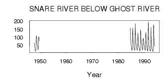
| PointID: | 3577 | Code: | 07SA002 | Latitude (decimal degrees): | 63.97 | Longitude (decimal degrees): | -115.43 | Drainage Area (km2): | 13300.00 | Source: | Hydat | Hydrological Zone: | Mackenzie | Name: | SNARE RIVER BELOW GHOST RIVER |
|---|
| Download | |
|---|---|
| Site Descriptor Information | Site Time Series Data |
| Link to all available data | |
| ID | Year | Jan | Feb | Mar | Apr | May | Jun | Jul | Aug | Sep | Oct | Nov | Dec |
|---|---|---|---|---|---|---|---|---|---|---|---|---|---|
| 3577 | 1947 | 65.50 | 52.00 | 42.00 | |||||||||
| 3577 | 1948 | 33.00 | 23.00 | 17.00 | 13.00 | 16.10 | 27.80 | 88.20 | 111.00 | 103.00 | 90.80 | 73.00 | 55.00 |
| 3577 | 1949 | 41.00 | 31.00 | 26.00 | 24.00 | 25.70 | 55.90 | 106.00 | 97.70 | 79.20 | |||
| 3577 | 1984 | 159.00 | 108.00 | 81.70 | 62.00 | 48.00 | |||||||
| 3577 | 1985 | 37.00 | 29.00 | 23.00 | 18.00 | 28.20 | 126.00 | 159.00 | 125.00 | 95.10 | 72.60 | 58.00 | 45.00 |
| 3577 | 1986 | 35.00 | 28.00 | 23.00 | 19.00 | 24.30 | 131.00 | 186.00 | 118.00 | 85.70 | 66.70 | 53.00 | 42.00 |
| 3577 | 1987 | 34.00 | 28.00 | 23.00 | 19.00 | 23.30 | 61.20 | 127.00 | 96.40 | 68.00 | 52.30 | 43.00 | 39.00 |
| 3577 | 1988 | 34.00 | 28.00 | 22.00 | 17.00 | 14.80 | 37.20 | 147.00 | 131.00 | 99.10 | 83.60 | 75.00 | 62.00 |
| 3577 | 1989 | 46.00 | 35.00 | 26.00 | 21.00 | 23.90 | 42.20 | 91.30 | 94.60 | 75.40 | 65.10 | 58.00 | 50.00 |
| 3577 | 1990 | 39.00 | 30.00 | 25.00 | 20.00 | 20.30 | 51.90 | 133.00 | 115.00 | 84.40 | 64.10 | 49.00 | 38.00 |
| 3577 | 1991 | 30.00 | 23.00 | 18.00 | 14.00 | 23.90 | 142.00 | 198.00 | 113.00 | 73.50 | 53.90 | 41.00 | 33.00 |
| 3577 | 1992 | 27.00 | 21.00 | 17.00 | 15.00 | 17.20 | 62.80 | 162.00 | 108.00 | 68.30 | 46.40 | 35.00 | 29.00 |
| 3577 | 1993 | 23.00 | 19.00 | 15.00 | 13.00 | 17.50 | 54.30 | 179.00 | 169.00 | 111.00 | 77.10 | 57.00 | 45.00 |
 Return to R-Arctic Net Home Page